IMAGES TAKEN NEAR TO
Torrance, GLASGOW, G64 4DJ
Introduction
This page details the photographs taken nearby to G64 4DJ by members of the Geograph project.
The Geograph project started in 2005 with the aim of publishing, organising and preserving representative images for every square kilometre of Great Britain, Ireland and the Isle of Man.

There are currently over 7.5m images from over14,400 individuals and you can help contribute to the project by visiting https://www.geograph.org.uk
Image Map
Images are licensed for reuse under creativecommons.org/licenses/by-sa/2.0
Notes
- Clicking on the map will re-center to the selected point.
- The higher the marker number, the further away the image location is from the centre of the postcode.
Image Listing (10 Images Found)
Images are licensed for reuse under creativecommons.org/licenses/by-sa/2.0
Image
Details
Distance
1
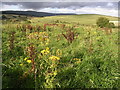
Meadow Flowers in Acre Valley
Looking north-east towards the Campsie Fells
Image: © Chris Upson
Taken: 31 Aug 2006
0.12 miles
2
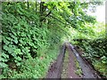
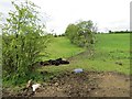
Road, Acre Valley
An unsealed and muddy road out of Torrance.
Image: © Richard Webb
Taken: 31 May 2013
0.12 miles

4
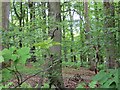
Woodland, Acre Valley
A small hill with a small wood on top.
Image: © Richard Webb
Taken: 31 May 2013
0.16 miles
5
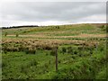
Langshot Farm
Rough and damp farmland some of which is now planted with trees.
Image: © Richard Webb
Taken: 31 May 2013
0.16 miles
7
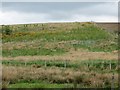
Langshot Woods
A newly planted wood on marginal farmland.
Image: © Richard Webb
Taken: 31 May 2013
0.19 miles

9

East Balgrochan to Acre Valley road
Unsealed road behind Torrance.
Image: © Richard Webb
Taken: 31 May 2013
0.20 miles
10

Across the Red Burn
Roughish grassland and a background of the Campsie escarpment.
Image: © Richard Webb
Taken: 31 May 2013
0.22 miles