IMAGES TAKEN NEAR TO
Balmore, Torrance, GLASGOW, G64 4AQ
Introduction
This page details the photographs taken nearby to G64 4AQ by members of the Geograph project.
The Geograph project started in 2005 with the aim of publishing, organising and preserving representative images for every square kilometre of Great Britain, Ireland and the Isle of Man.

There are currently over 7.5m images from over14,400 individuals and you can help contribute to the project by visiting https://www.geograph.org.uk
Image Map
Images are licensed for reuse under creativecommons.org/licenses/by-sa/2.0
Notes
- Clicking on the map will re-center to the selected point.
- The higher the marker number, the further away the image location is from the centre of the postcode.
Image Listing (8 Images Found)
Images are licensed for reuse under creativecommons.org/licenses/by-sa/2.0
Image
Details
Distance
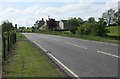
1
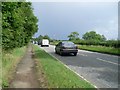
Queueing traffic on Balmore Road
Approaching the village of Balmore from the west.
Image: © Stephen Sweeney
Taken: 15 Jul 2009
0.07 miles
2
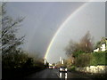
Rainbow to the west of Colbeg
Taken at 08.45 hrs
Image: © Dumgoyach
Taken: 14 Nov 2006
0.09 miles
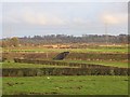
4
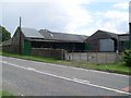
Farm buildings at Laverockhill
By Balmore Road.
Image: © Stephen Sweeney
Taken: 15 Jul 2009
0.17 miles
5
Colbeg Kennels and Cattery
Beside the A807.
Image: © Richard Sutcliffe
Taken: 28 May 2016
0.17 miles
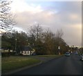
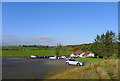
6
Embankment, Balmore Haughs
The trackbed of Kelvin Valley Railway which closed to passenger traffic in 1961.
Image: © Richard Webb
Taken: 19 Jan 2014
0.23 miles
7
Balmore Golf Course club house
One of the three golf courses I pass between Cadder and Milngavie
Image: © Tim Heaton
Taken: 10 Oct 2018
0.23 miles
8
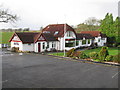
Balmore Golf Club - Clubhouse
Par 66 golf course designed by six-time British Open Champion Harry Vardon and set in beautiful surroundings which once formed Glenorchard Country Estate.
Image: © G Laird
Taken: 25 Dec 2013
0.24 miles