IMAGES TAKEN NEAR TO
Croft Road, GLASGOW, G64 4AL
Introduction
This page details the photographs taken nearby to Croft Road, G64 4AL by members of the Geograph project.
The Geograph project started in 2005 with the aim of publishing, organising and preserving representative images for every square kilometre of Great Britain, Ireland and the Isle of Man.

There are currently over 7.5m images from over14,400 individuals and you can help contribute to the project by visiting https://www.geograph.org.uk
Image Map (Loading...)


Getting Data...Please wait
Leaflet Map data © OpenStreetMap
Images are licensed for reuse under creativecommons.org/licenses/by-sa/2.0
Notes
- Clicking on the map will re-center to the selected point.
- The higher the marker number, the further away the image location is from the centre of the postcode.
Image Listing (40 Images Found)
Images are licensed for reuse under creativecommons.org/licenses/by-sa/2.0
Image
Details
Distance
1
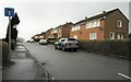
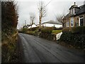
Croft Road
A residential cul-de-sac in Balmore.
Image: © Richard Sutcliffe
Taken: 3 Feb 2022
0.02 miles
2
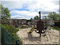
Playground, Croft Road
Park in a loop of Croft Road.
Image: © Richard Webb
Taken: 31 May 2013
0.03 miles
3
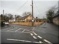
Road junction, Balmore
The main road here (to the right) is Glenorchard Road. Bearing slightly to the left is Golf Course Road, which unsurprisingly leads to Balmore Golf Club. Hard left is Croft Road.
Image: © Richard Sutcliffe
Taken: 3 Feb 2022
0.04 miles
4
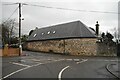
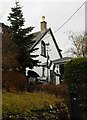
Newlands, Balmore
A residential property that looks like it has a bit of a history to it. The building is shown on the 1st edition of the 25 inch to the mile OS map of 1863.
Image: © Richard Sutcliffe
Taken: 3 Feb 2022
0.04 miles
5
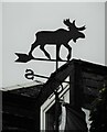
An unusual weathervane
In the shape of a moose on top of a short flagpole beside a house in Balmore Image
Image: © Richard Sutcliffe
Taken: 3 Feb 2022
0.07 miles
6
House with a moose
The moose in question is a weathervane on top of a short flagpole beside the house in Balmore.
Image: © Richard Sutcliffe
Taken: 3 Feb 2022
0.07 miles
7
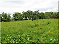
Field, Balmore
At the end of Croft Road.
Image: © Richard Webb
Taken: 31 May 2013
0.07 miles
9
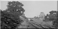
Balmore Station (site)
View eastwards (towards Kilsyth) to what little remained of the station: Maryhill to Kilsyth line, closed to passengers 2/4/51, to Goods 31/7/61 - shortly before this photograph was taken.
Image: © Ben Brooksbank
Taken: 5 Oct 1961
0.09 miles
10
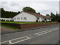
Cadder View, Balmore Road
This bungalow is built on land formerly used by the Kelvin Valley Railway. The track crossed the roadway at this point on its way to Kilsyth.
Image: © Raymond Okonski
Taken: 15 Sep 2007
0.11 miles