IMAGES TAKEN NEAR TO
Buchley, GLASGOW, G64 3QN
Introduction
This page details the photographs taken nearby to Buchley, G64 3QN by members of the Geograph project.
The Geograph project started in 2005 with the aim of publishing, organising and preserving representative images for every square kilometre of Great Britain, Ireland and the Isle of Man.

There are currently over 7.5m images from over14,400 individuals and you can help contribute to the project by visiting https://www.geograph.org.uk
Image Map
Images are licensed for reuse under creativecommons.org/licenses/by-sa/2.0
Notes
- Clicking on the map will re-center to the selected point.
- The higher the marker number, the further away the image location is from the centre of the postcode.
Image Listing (7 Images Found)
Images are licensed for reuse under creativecommons.org/licenses/by-sa/2.0
Image
Details
Distance
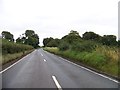
1
Farmhouses at Buchley
With the Campsie Fells in the background.
Image: © G Laird
Taken: 23 Oct 2010
0.03 miles
3
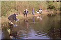
Surveying for amphibians, Buchley
Members of the Clyde Amphibian and Reptile Group (CARG), surveying for newts and other amphibians in a pond near Buckley Farm, in spring 2002.
Image: © Richard Sutcliffe
Taken: Unknown
0.20 miles
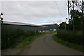
4
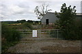
Gates, Buchley Farm
The sign on the first gate refers to access to towers (electricity pylons) in the adjacent field.
Image: © Richard Sutcliffe
Taken: 15 Sep 2015
0.21 miles
5
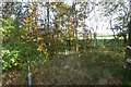
View through a stripwood
Beside the road into Buckley
Image: © Richard Webb
Taken: 30 Oct 2015
0.23 miles
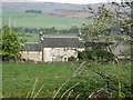
6
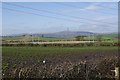
Strathkelvin
View from Buckley over the site of a Roman camp.
Image: © Richard Webb
Taken: 30 Oct 2015
0.23 miles