IMAGES TAKEN NEAR TO
Westfields, GLASGOW, G64 3PL
Introduction
This page details the photographs taken nearby to Westfields, G64 3PL by members of the Geograph project.
The Geograph project started in 2005 with the aim of publishing, organising and preserving representative images for every square kilometre of Great Britain, Ireland and the Isle of Man.

There are currently over 7.5m images from over14,400 individuals and you can help contribute to the project by visiting https://www.geograph.org.uk
Image Map
Images are licensed for reuse under creativecommons.org/licenses/by-sa/2.0
Notes
- Clicking on the map will re-center to the selected point.
- The higher the marker number, the further away the image location is from the centre of the postcode.
Image Listing (35 Images Found)
Images are licensed for reuse under creativecommons.org/licenses/by-sa/2.0
Image
Details
Distance
1

Footpath beside the canal
This footpath runs on the south side of the Forth and Clyde Canal from the Bishopbriggs Leisuredrome to Lambhill. It is a quieter path to walk than the towpath on the other side of the canal, but a bit muddier in places.
Image: © Richard Sutcliffe
Taken: 25 Jan 2022
0.08 miles
2

Footpath beside the canal
This footpath runs on the south side of the Forth and Clyde Canal from the Bishopbriggs Leisuredrome to Lambhill. It is a quieter path to walk than the towpath on the other side of the canal, but a bit muddier in places.
Image: © Richard Sutcliffe
Taken: 25 Jan 2022
0.09 miles
3

A hanging trunk
The large trunk on the right is not levitating; in fact it is being held in place by crossing branches higher up. It did look potentially dangerous though.
See Image for a view 30 minutes later.
Image: © Richard Sutcliffe
Taken: 25 Jan 2022
0.10 miles
4

Felled trunk
Exactly half an hour after taking a photograph of a dangerous tree Image I was returning towards the same area when I heard a very loud crash. In the time I had been away, workmen had arrived with a tractor and had presumably pushed the trunk over, as it was now lying on the ground. (This photograph was taken from the other side of the Bishopbriggs Burn, in the dip in the foreground.)
Image: © Richard Sutcliffe
Taken: 25 Jan 2022
0.10 miles
5

Gate beside a footbridge
The bridge behind crosses the Bishopbriggs Burn.
Image: © Richard Sutcliffe
Taken: 25 Jan 2022
0.10 miles
6
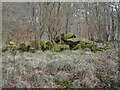
A pile of large stones
A pile of large, moss-covered stones, which from a distance appear to be sandstone. Old maps do not show former buildings here, so presumably the rubble has just been dumped.
Image: © Richard Sutcliffe
Taken: 25 Jan 2022
0.11 miles
7
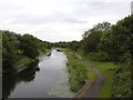
Forth and Clyde Canal and towpath at Farm Bridge
Looking west from the road bridge (Balmuildy Road). There are plenty of water lilies visible in the water.
Image: © Richard Sutcliffe
Taken: 27 Jul 2015
0.11 miles
8

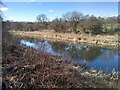
Bishopbriggs Burn
Looking from a bridge over the burn. The burn follows a straight line, as its original route was disrupted by the creation of the Forth and Clyde Canal (about 30 metres to the north).
Image: © Richard Sutcliffe
Taken: 25 Jan 2022
0.11 miles
9
Forth and Clyde Canal
Just west of Farm Bridge.
Image: © Richard Sutcliffe
Taken: 5 Mar 2022
0.12 miles
10
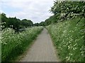
Wild flowers by canal path
North of Bishopbriggs.
Image: © Stephen Sweeney
Taken: 3 Jun 2009
0.14 miles