IMAGES TAKEN NEAR TO
Faskally Avenue, GLASGOW, G64 3PJ
Introduction
This page details the photographs taken nearby to Faskally Avenue, G64 3PJ by members of the Geograph project.
The Geograph project started in 2005 with the aim of publishing, organising and preserving representative images for every square kilometre of Great Britain, Ireland and the Isle of Man.

There are currently over 7.5m images from over14,400 individuals and you can help contribute to the project by visiting https://www.geograph.org.uk
Image Map
Images are licensed for reuse under creativecommons.org/licenses/by-sa/2.0
Notes
- Clicking on the map will re-center to the selected point.
- The higher the marker number, the further away the image location is from the centre of the postcode.
Image Listing (7 Images Found)
Images are licensed for reuse under creativecommons.org/licenses/by-sa/2.0
Image
Details
Distance
2
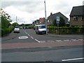
Balmuildy Road, Bishopbriggs
Approaching the junction with Hilton Road.
Image: © Stephen Sweeney
Taken: 27 May 2009
0.22 miles
3
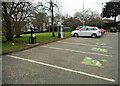
Electric vehicle charging points
In the car park at the Leisuredome, Bishopbriggs.
Image: © Richard Sutcliffe
Taken: 25 Jan 2022
0.23 miles
4
Balmuildy Road/Hilton Road
In Bishopbriggs.
Image: © Stephen Sweeney
Taken: 27 May 2009
0.24 miles
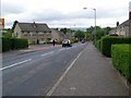
5

Lomond Road shops
In Bishopbriggs, just off Balmuildy Road.
Image: © Stephen Sweeney
Taken: 27 May 2009
0.24 miles
6

The Leisuredrome
Leisure centre on Balmuildry Road, Bishopbriggs, run by East Dunbartonshire Council.
Image: © Richard Sutcliffe
Taken: 25 Jan 2022
0.24 miles
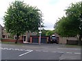
7

Entrance to the Leisuredrome
Run by East Dunbartonshire Council.
Image: © Richard Sutcliffe
Taken: 25 Jan 2022
0.25 miles