IMAGES TAKEN NEAR TO
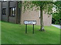
Teviot Avenue, GLASGOW, G64 3ND
Introduction
This page details the photographs taken nearby to Teviot Avenue, G64 3ND by members of the Geograph project.
The Geograph project started in 2005 with the aim of publishing, organising and preserving representative images for every square kilometre of Great Britain, Ireland and the Isle of Man.

There are currently over 7.5m images from over14,400 individuals and you can help contribute to the project by visiting https://www.geograph.org.uk
Image Map (Loading...)


Getting Data...Please wait
Leaflet Map data © OpenStreetMap
Images are licensed for reuse under creativecommons.org/licenses/by-sa/2.0
Notes
- Clicking on the map will re-center to the selected point.
- The higher the marker number, the further away the image location is from the centre of the postcode.
Image Listing (17 Images Found)
Images are licensed for reuse under creativecommons.org/licenses/by-sa/2.0
Image
Details
Distance
1
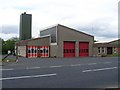
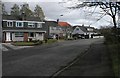
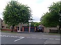
Bishopbriggs Fire Station
Community fire station on Hilton Road.
Image: © Stephen Sweeney
Taken: 27 May 2009
0.10 miles
2
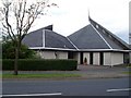
Church of St James the Less
Hilton Road, Bishopbriggs.
Image: © Stephen Sweeney
Taken: 27 May 2009
0.12 miles
3
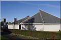
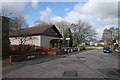
St James the Less
Episcopalian church on Hilton Road, Bishopbriggs.
Image: © Richard Webb
Taken: 30 Oct 2015
0.12 miles
7
Kingdom Hall, Bishopbriggs
Kingdom Hall of Jehovah's Witnesses, Hilton Terrace, Bishopbriggs.
Image: © Richard Sutcliffe
Taken: 28 Mar 2016
0.19 miles
9
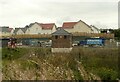
New electricity substation
Part of the infrastructure for the new houses being built by CALA Homes beside the canal at Jellyhill.
Image: © Richard Sutcliffe
Taken: 10 Sep 2021
0.21 miles
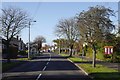
10
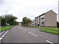
Balmuildy Road/Hilton Road
In Bishopbriggs.
Image: © Stephen Sweeney
Taken: 27 May 2009
0.22 miles