IMAGES TAKEN NEAR TO
Kirkstall Gardens, GLASGOW, G64 3JQ
Introduction
This page details the photographs taken nearby to Kirkstall Gardens, G64 3JQ by members of the Geograph project.
The Geograph project started in 2005 with the aim of publishing, organising and preserving representative images for every square kilometre of Great Britain, Ireland and the Isle of Man.

There are currently over 7.5m images from over14,400 individuals and you can help contribute to the project by visiting https://www.geograph.org.uk
Image Map
Images are licensed for reuse under creativecommons.org/licenses/by-sa/2.0
Notes
- Clicking on the map will re-center to the selected point.
- The higher the marker number, the further away the image location is from the centre of the postcode.
Image Listing (42 Images Found)
Images are licensed for reuse under creativecommons.org/licenses/by-sa/2.0
Image
Details
Distance
2
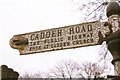
Cadder Road
Locals loved their 'rustic' sign, which had stood on the corner of Cadder and Kirkintilloch Roads it seemed, for ever. This, and the supporting black and white banded metal post became a popular landmark, until one day the sign itself vanished. The pole still remains to this day, but the sign was broken off (illegally) and possibly sold off for scrap.
Image: © Raymond Okonski
Taken: 1 Mar 1986
0.07 miles
3
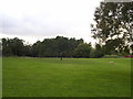
Meadowburn Parkland, Cadder
Secluded area of parkland at the end of Kirkstall Gardens. The trees in the distance belong to Meadowburn Wood.
Image: © Chris Upson
Taken: 25 Sep 2005
0.12 miles
4
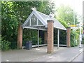
Bus shelter on Kirkintilloch Road
Opposite Cadder Road.
Image: © Stephen Sweeney
Taken: 3 Jun 2009
0.13 miles
5
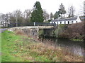
Bridge over the Forth and Clyde Canal
In the northern outskirts of Bishopbriggs.
Image: © G Laird
Taken: 20 Nov 2010
0.14 miles
6
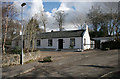
Cadder Bridge Cottages
The cottages are Category B listed.
Image: © Richard Sutcliffe
Taken: 4 Mar 2020
0.14 miles
7
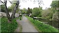
Forth and Clyde Canal
The towpath, a cycle route, near a bridge at Cadder.
Image: © Richard Webb
Taken: 9 May 2012
0.14 miles
8
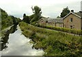
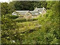
Forth and Clyde Canal and Cawdermill House
Late 18th century Category C listed former stables beside the Forth and Clyde Canal. It was one of the first combined stables and inn buildings located along the canal http://portal.historicenvironment.scot/designation/LB22279.
Image: © Richard Sutcliffe
Taken: 10 Sep 2021
0.14 miles
9
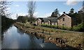
Cawdermill House
Late 18th century Category C listed former stables beside the Forth and Clyde Canal. It was one of the first combined stables and inn buildings located along the canal http://portal.historicenvironment.scot/designation/LB22279.
Seen from the path on the south side of the canal.
Image: © Richard Sutcliffe
Taken: 10 Sep 2021
0.14 miles
10
Cawdermill House
Late 18th century Category C listed former stables beside the Forth and Clyde Canal. It was one of the first combined stables and inn buildings located along the canal http://portal.historicenvironment.scot/designation/LB22279.
A couple of anglers are trying their luck beside the canal.
Image: © Richard Sutcliffe
Taken: 4 Mar 2020
0.14 miles