IMAGES TAKEN NEAR TO
Melville Gardens, GLASGOW, G64 3DF
Introduction
This page details the photographs taken nearby to Melville Gardens, G64 3DF by members of the Geograph project.
The Geograph project started in 2005 with the aim of publishing, organising and preserving representative images for every square kilometre of Great Britain, Ireland and the Isle of Man.

There are currently over 7.5m images from over14,400 individuals and you can help contribute to the project by visiting https://www.geograph.org.uk
Image Map
Images are licensed for reuse under creativecommons.org/licenses/by-sa/2.0
Notes
- Clicking on the map will re-center to the selected point.
- The higher the marker number, the further away the image location is from the centre of the postcode.
Image Listing (39 Images Found)
Images are licensed for reuse under creativecommons.org/licenses/by-sa/2.0
Image
Details
Distance
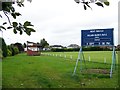
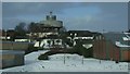
1
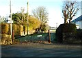
Closed off road
The road leads off Wester Cleddens Road towards the recreation ground in the distance.
Image: © Richard Sutcliffe
Taken: 15 Feb 2019
0.09 miles
2
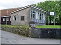
War Memorial Hall
Behind a church in Bishopbriggs.
Image: © Stephen Sweeney
Taken: 27 May 2009
0.09 miles
3
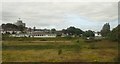
Early Learning and Childcare centre, Bishopbriggs
Bishopbriggs water tower behind.
Image: © Alan Reid
Taken: 29 Jul 2020
0.11 miles
4
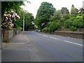
Kirkintilloch Road
Approaching the bend at Balmuildy Road.
Image: © Stephen Sweeney
Taken: 27 May 2009
0.11 miles
6
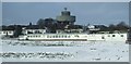
Bearyards water tower
Viewed from an Edinburgh bound train near Bishopbriggs station. See Image for more information about the tower.
Image: © Thomas Nugent
Taken: 10 Jan 2010
0.11 miles
7
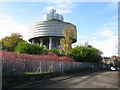
Bishopbriggs Water Tower
Now also adorned with a variety of mobile phone masts.
Image: © G Laird
Taken: 23 Oct 2010
0.11 miles
8
Wester Cleddans Road water tower
Also known as Bearyards water tower. Viewed from Bishopbriggs railway station footbridge.
See Image for more details of the water tower.
Image: © Thomas Nugent
Taken: 24 Aug 2013
0.12 miles
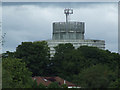
9
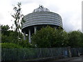
Bearyards Water Tower
This water tower is typical of many in west Central Scotland and particularly Glasgow. Erected on a high point in the town, it allowed the (then) Lanarkshire Water Board to pump water up the tower to fill the reservoir, which in turn gave all the houses nearby increased water pressure from their taps. In the mid 1990's One-2-One (now T-Mobile) received permission to add a mobile phone base station to the top, and after many planning appeals, Vodafone, Orange and O2 joined them, but their antennae are hidden behind the latticework 'top hat' on the tank roof.
Image: © Raymond Okonski
Taken: 25 May 2007
0.12 miles
10
Bearyards water tower
Viewed from an Edinburgh bound train, near Bishopbriggs station. See Image for more information about the tower.
Image: © Thomas Nugent
Taken: 10 Jan 2010
0.12 miles