IMAGES TAKEN NEAR TO
Southesk Avenue, GLASGOW, G64 3AE
Introduction
This page details the photographs taken nearby to Southesk Avenue, G64 3AE by members of the Geograph project.
The Geograph project started in 2005 with the aim of publishing, organising and preserving representative images for every square kilometre of Great Britain, Ireland and the Isle of Man.

There are currently over 7.5m images from over14,400 individuals and you can help contribute to the project by visiting https://www.geograph.org.uk
Image Map
Images are licensed for reuse under creativecommons.org/licenses/by-sa/2.0
Notes
- Clicking on the map will re-center to the selected point.
- The higher the marker number, the further away the image location is from the centre of the postcode.
Image Listing (7 Images Found)
Images are licensed for reuse under creativecommons.org/licenses/by-sa/2.0
Image
Details
Distance
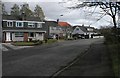
2

Lomond Road shops
In Bishopbriggs, just off Balmuildy Road.
Image: © Stephen Sweeney
Taken: 27 May 2009
0.16 miles
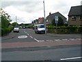
3
Balmuildy Road, Bishopbriggs
Approaching the junction with Hilton Road.
Image: © Stephen Sweeney
Taken: 27 May 2009
0.17 miles
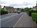
4
Balmuildy Road/Hilton Road
In Bishopbriggs.
Image: © Stephen Sweeney
Taken: 27 May 2009
0.20 miles
5
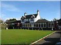
Bishopbriggs Golf Club - Clubhouse
Established in 1906 within the boundaries of the original Kenmure Estate, the golf course lies close to the centre of Bishopbriggs.
Image: © G Laird
Taken: 23 Oct 2010
0.22 miles
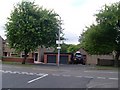
7
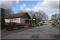
Kingdom Hall, Bishopbriggs
Kingdom Hall of Jehovah's Witnesses, Hilton Terrace, Bishopbriggs.
Image: © Richard Sutcliffe
Taken: 28 Mar 2016
0.25 miles