IMAGES TAKEN NEAR TO
Park Avenue, GLASGOW, G64 2SN
Introduction
This page details the photographs taken nearby to Park Avenue, G64 2SN by members of the Geograph project.
The Geograph project started in 2005 with the aim of publishing, organising and preserving representative images for every square kilometre of Great Britain, Ireland and the Isle of Man.

There are currently over 7.5m images from over14,400 individuals and you can help contribute to the project by visiting https://www.geograph.org.uk
Image Map
Images are licensed for reuse under creativecommons.org/licenses/by-sa/2.0
Notes
- Clicking on the map will re-center to the selected point.
- The higher the marker number, the further away the image location is from the centre of the postcode.
Image Listing (12 Images Found)
Images are licensed for reuse under creativecommons.org/licenses/by-sa/2.0
Image
Details
Distance
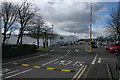
1

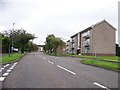
Asda car park and new houses
The houses are new enough not to appear yet on Google Maps, although they are present on the OS map.
Image: © Richard Sutcliffe
Taken: 28 Mar 2016
0.02 miles
4
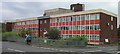
Wimpey Worldwide / Carillion
This building was the Scottish headquarters of the housebuilders Wimpey, who had extensive developments in and around Bishopbriggs. The building was subsequently taken over by Carillion, before being demolished in 2002-3 to make way for yet more housing.
Image: © Raymond Okonski
Taken: 22 Aug 2002
0.07 miles
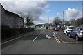
5
Asda Bishopbriggs
Behind the bus stop on Kirkintilloch Road.
Image: © Stephen Sweeney
Taken: 27 May 2009
0.07 miles
6
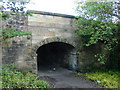
Mavis Valley Railway Bridge
This little bridge is a treasure many local residents are unaware of unless they look carefully.
Above thunders the traffic on the A803 Kirkintilloch to Glasgow road, but this little bridge allowed the mineral railway (single track) access all the way from Cadder Sidings to the Mavis Valley mine workings.
Today, the bridge is used only as a pedestrian walkway under Kirkintilloch Road. The stone bridge portal can only be seen from this side (looking east) as the A803 was widened and a concrete portal added on the other side.
Image: © Raymond Okonski
Taken: 25 May 2007
0.14 miles
7
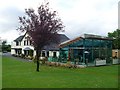
Oregano at the Eagle Lodge
Restaurant in Bishopbriggs.
Image: © Stephen Sweeney
Taken: 27 May 2009
0.14 miles
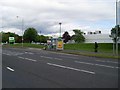
8
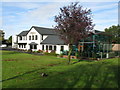
The Eagle Lodge, Bishopbriggs
At the corner of Kirkintilloch Road and Hilton Road.
Image: © G Laird
Taken: 23 Oct 2010
0.15 miles
10
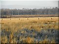
Fence, High Moss
Zoomed image, looking across High Moss (a Local Nature Conservation Site) towards High Moss Plantation.
Image: © Richard Sutcliffe
Taken: 15 Feb 2019
0.20 miles