IMAGES TAKEN NEAR TO
Westerhill Road, GLASGOW, G64 2QT
Introduction
This page details the photographs taken nearby to Westerhill Road, G64 2QT by members of the Geograph project.
The Geograph project started in 2005 with the aim of publishing, organising and preserving representative images for every square kilometre of Great Britain, Ireland and the Isle of Man.

There are currently over 7.5m images from over14,400 individuals and you can help contribute to the project by visiting https://www.geograph.org.uk
Image Map
Images are licensed for reuse under creativecommons.org/licenses/by-sa/2.0
Notes
- Clicking on the map will re-center to the selected point.
- The higher the marker number, the further away the image location is from the centre of the postcode.
Image Listing (11 Images Found)
Images are licensed for reuse under creativecommons.org/licenses/by-sa/2.0
Image
Details
Distance
1
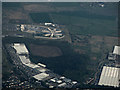
HM Prison Low Moss from the air
The prison closed in 2007 and a new, substantially larger medium security prison was constructed on the same site. This was also the site of the Former RAF Bishopbriggs which was a barrage balloon depot. Strathkelvin Retail Park is also prominent.
Image: © Thomas Nugent
Taken: 1 May 2017
0.07 miles
2
HM Prison Low Moss from the air
The prison closed in 2007 and a new, substantially larger medium security prison was constructed on the same site. This was also the site of the Former RAF Bishopbriggs which was a barrage balloon depot. Strathkelvin Retail Park is also prominent.
Image: © Thomas Nugent
Taken: 1 May 2017
0.07 miles
3
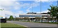
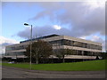
Harper Collins
Publisher's offices on Westerhill Road.
Image: © Richard Webb
Taken: 31 May 2013
0.10 miles
4
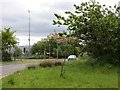
Westerhill Road
Very much an industrial area on the northern edge of Bishopbriggs.
Image: © Richard Webb
Taken: 31 May 2013
0.12 miles
5
Harper-Collins Offices
Harper-Collins Offices at Bishopbriggs
Image: © Chris Upson
Taken: 25 Sep 2005
0.13 miles
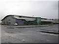
6
Harper Collins Publishers
Publishing offices in Westerhill Business Park, Bishopbriggs.
Image: © Stephen Sweeney
Taken: 3 Jun 2009
0.14 miles
7
Aviva Call Centre
Formerly Image prior to the insurance company Norwich Union being renamed Aviva.
Image: © G Laird
Taken: 25 Dec 2013
0.19 miles
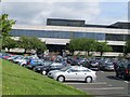
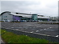
8
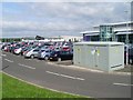
Car Park at Westerhill Business Park
At the Norwich Union/Aviva RAC call centre.
Image: © Stephen Sweeney
Taken: 3 Jun 2009
0.20 miles
9
Norwich Union RAC Insurance Call Centre
This purpose-built call centre was created on a greenfield site close to their original offices (in the Harper-Collins building), nearby. The erection of the building was conditional on the creation of a roundabout on the north side of the railway bridge, currently unshown on the OS map.
Image: © Raymond Okonski
Taken: 22 Apr 2007
0.22 miles
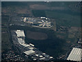
10
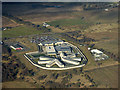
HM Prison Low Moss from the air
The prison closed in 2007 and a new, substantially larger medium security prison was constructed on the same site. This was also the site of the Former RAF Bishopbriggs which was a barrage balloon depot. Strathkelvin Retail Park is also prominent.
See also Image
Image: © Thomas Nugent
Taken: 9 Feb 2018
0.23 miles