IMAGES TAKEN NEAR TO
Crosshill Road, GLASGOW, G64 2QB
Introduction
This page details the photographs taken nearby to Crosshill Road, G64 2QB by members of the Geograph project.
The Geograph project started in 2005 with the aim of publishing, organising and preserving representative images for every square kilometre of Great Britain, Ireland and the Isle of Man.

There are currently over 7.5m images from over14,400 individuals and you can help contribute to the project by visiting https://www.geograph.org.uk
Image Map
Images are licensed for reuse under creativecommons.org/licenses/by-sa/2.0
Notes
- Clicking on the map will re-center to the selected point.
- The higher the marker number, the further away the image location is from the centre of the postcode.
Image Listing (12 Images Found)
Images are licensed for reuse under creativecommons.org/licenses/by-sa/2.0
Image
Details
Distance
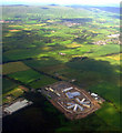
1
Low Moss Prison
Low Moss Prison houses 330 medium to low supervision male adult prisoners sentenced to less than 48 months.
Image: © Chris Upson
Taken: 25 Sep 2005
0.01 miles
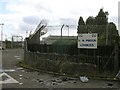
2
Former RAF Bishopbriggs
An area of concrete hardstanding just off the B819, Crosshill Road. The hardstanding is part of the former RAF Bishopbriggs, a World War II barrage balloon depot and barracks. See Canmore https://canmore.org.uk/site/105796/cadder. The structure on the right is the remains of a water tower Image
Image: © Richard Sutcliffe
Taken: 28 Feb 2023
0.06 miles
3
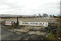
Football Parking Only
A banner on the gate to an area of concrete hardstanding just off the B819, Crosshill Road. Football goalposts are stacked in the background. The hardstanding is part of the former RAF Bishopbriggs, a World War II barrage balloon depot and barracks. See Canmore https://canmore.org.uk/site/105796/cadder.
Image: © Richard Sutcliffe
Taken: 28 Feb 2023
0.10 miles
4
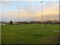
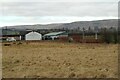
Loretto Playing Field
Sports ground, Low Moss.
Image: © Richard Webb
Taken: 19 Jan 2014
0.12 miles
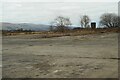
5
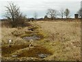
Former roadway
Part of the former RAF Bishopbriggs, a World War II barrage balloon depot and barracks. See Canmore https://canmore.org.uk/site/105796/cadder. A former water tower can be seen top right.
Image: © Richard Sutcliffe
Taken: 28 Feb 2023
0.13 miles
6
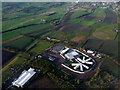
HMP Low Moss from the air
The prison closed in 2007 and a new, substantially larger medium security prison was constructed on the same site. This was also the site of the Former RAF Bishopbriggs which was a barrage balloon depot.
The late evening sun highlights the course of the Antonine Wall which runs from the bottom left to the top right of the photo. This was the northern limit of the Roman Empire http://www.antoninewall.org/ .
See a similar view of the prison under construction here Image
Image: © Thomas Nugent
Taken: 11 May 2012
0.15 miles
7
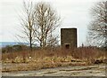
Water tower, RAF Bishopbriggs
The remains of a water tower, beside an area of concrete hardstanding just off the B819, Crosshill Road. The hardstanding is part of the former RAF Bishopbriggs, a World War II barrage balloon depot and barracks. See Canmore https://canmore.org.uk/site/105796/cadder.
Image: © Richard Sutcliffe
Taken: 28 Feb 2023
0.16 miles
8
Bishopbriggs Golf Range & Golf Superstore
A place to practice your golf shots.
Image: © Richard Sutcliffe
Taken: 28 Feb 2023
0.17 miles
10
HMP Low Moss from the air
The prison closed in 2007 and a new, substantially larger medium security prison is being constructed on the same site. This was also the site of the Former RAF Bishopbriggs which was a barrage balloon depot.
See the same scene in May 2012 Image
Image: © Thomas Nugent
Taken: 28 Jun 2011
0.23 miles