IMAGES TAKEN NEAR TO
Kirkintilloch Road, GLASGOW, G64 2LX
Introduction
This page details the photographs taken nearby to Kirkintilloch Road, G64 2LX by members of the Geograph project.
The Geograph project started in 2005 with the aim of publishing, organising and preserving representative images for every square kilometre of Great Britain, Ireland and the Isle of Man.

There are currently over 7.5m images from over14,400 individuals and you can help contribute to the project by visiting https://www.geograph.org.uk
Image Map
Images are licensed for reuse under creativecommons.org/licenses/by-sa/2.0
Notes
- Clicking on the map will re-center to the selected point.
- The higher the marker number, the further away the image location is from the centre of the postcode.
Image Listing (108 Images Found)
Images are licensed for reuse under creativecommons.org/licenses/by-sa/2.0
Image
Details
Distance
1
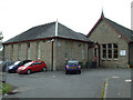
Bishopbriggs Library
The rear of the Gothic style Category B Listed former school building http://data.historic-scotland.gov.uk/pls/htmldb/f?p=2200:15:0::::BUILDING:22286 .
Image: © Thomas Nugent
Taken: 24 Aug 2013
0.00 miles
2
Bishopbriggs Library
The rear of the Gothic style Category B Listed former school building http://data.historic-scotland.gov.uk/pls/htmldb/f?p=2200:15:0::::BUILDING:22286 .
Image: © Thomas Nugent
Taken: 24 Aug 2013
0.01 miles
3
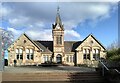
Bishopbriggs Library and Community Hub
Originally built as Bishopbriggs High School, it opened in 1896. For many years it has been Bishopbriggs' library. More recently it has become the Community Hub, home for Council, library and cultural services in the town. It is Category B listed http://portal.historicenvironment.scot/designation/LB22286.
Image: © Richard Sutcliffe
Taken: 5 Mar 2022
0.01 miles
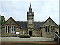
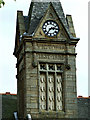
4

Clock tower, Bishopbriggs Library and Community Hub
Originally built as Bishopbriggs High School, it opened in 1896. For many years it has been Bishopbriggs' library. More recently it has become the Community Hub, home for Council, library and cultural services in the town. It is Category B listed http://portal.historicenvironment.scot/designation/LB22286.
Below the clock it reads:
VICTORIA
1837-1897
and above the door:
CADDER PARISH
SCHOOL BOARD
Image: © Richard Sutcliffe
Taken: 5 Mar 2022
0.01 miles
5
Bishopbriggs Library
A Gothic style Category B Listed former school building http://data.historic-scotland.gov.uk/pls/htmldb/f?p=2200:15:0::::BUILDING:22286 .
See also Image
Image: © Thomas Nugent
Taken: 24 Aug 2013
0.01 miles
6
Bishopbriggs Library tower
A Gothic style Category B Listed former school building http://data.historic-scotland.gov.uk/pls/htmldb/f?p=2200:15:0::::BUILDING:22286 .
See also Image
Image: © Thomas Nugent
Taken: 24 Aug 2013
0.01 miles
7
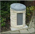
Cadder Pit Disaster Memorial
In memory of the 22 miners who lost their lives in the disaster of August 1913. Located outside Bishopbriggs Library.
See also Image & Image
Image: © Thomas Nugent
Taken: 24 Aug 2013
0.02 miles
8
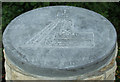
Cadder Pit Disaster Memorial
In memory of the 22 miners who lost their lives in the disaster of August 1913. Located outside Bishopbriggs Library.
See also Image & Image
Image: © Thomas Nugent
Taken: 24 Aug 2013
0.02 miles
9

Cadder Pit Disaster Memorial
In memory of the 22 miners who lost their lives in the disaster of August 1913. Located outside Bishopbriggs Library.
See also Image & Image
Image: © Thomas Nugent
Taken: 24 Aug 2013
0.02 miles
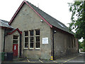
10
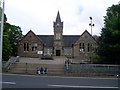
Bishopbriggs Library
Fine public building on Kirkintilloch Road.
Image: © Stephen Sweeney
Taken: 27 May 2009
0.02 miles