IMAGES TAKEN NEAR TO
Kirkintilloch Road, GLASGOW, G64 2JA
Introduction
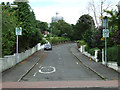
This page details the photographs taken nearby to Kirkintilloch Road, G64 2JA by members of the Geograph project.
The Geograph project started in 2005 with the aim of publishing, organising and preserving representative images for every square kilometre of Great Britain, Ireland and the Isle of Man.

There are currently over 7.5m images from over14,400 individuals and you can help contribute to the project by visiting https://www.geograph.org.uk
Image Map
Images are licensed for reuse under creativecommons.org/licenses/by-sa/2.0
Notes
- Clicking on the map will re-center to the selected point.
- The higher the marker number, the further away the image location is from the centre of the postcode.
Image Listing (98 Images Found)
Images are licensed for reuse under creativecommons.org/licenses/by-sa/2.0
Image
Details
Distance
1
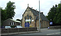
Cadder South Halls
The halls of the two miles distant Cadder Parish Church.
Image: © Thomas Nugent
Taken: 24 Aug 2013
0.01 miles
2
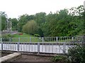
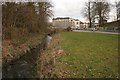
Wooded area around Bishopbriggs Burn
Seen from Kirkintilloch Road.
Image: © Stephen Sweeney
Taken: 27 May 2009
0.05 miles
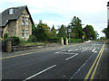
3
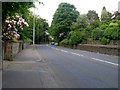
Kirkintilloch Road
Approaching the bend at Balmuildy Road.
Image: © Stephen Sweeney
Taken: 27 May 2009
0.05 miles
4
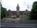
Bishopbriggs Library
Fine public building on Kirkintilloch Road.
Image: © Stephen Sweeney
Taken: 27 May 2009
0.06 miles
5
Flats on Kenmure Drive
Viewed from Bishopbriggs Public Park. The Bishopbriggs Burn runs alongside the Rookery Plantation on the left.
Image: © Richard Sutcliffe
Taken: 9 Mar 2017
0.07 miles
6
South Crosshill Road
Viewed from the junction with Kirkintilloch Road.
Image: © Thomas Nugent
Taken: 24 Aug 2013
0.07 miles
7
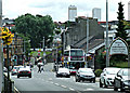
Bishopbriggs town centre
Looking south along Kirkintilloch Road at South Crosshill Road.
Image: © Thomas Nugent
Taken: 24 Aug 2013
0.07 miles
8
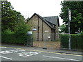
Crosshill House
Former community health services centre, closed in February 2012 when services relocated to Stobhill Hospital in Glasgow. Located on South Crosshill Road.
Image: © Thomas Nugent
Taken: 24 Aug 2013
0.07 miles
9
Boclair Road
Off South Crosshill Road. Wester Cleddans Road water tower can be seen on the horizon.
Image: © Thomas Nugent
Taken: 24 Aug 2013
0.07 miles
10

Cadder Pit Disaster Memorial
In memory of the 22 miners who lost their lives in the disaster of August 1913. Located outside Bishopbriggs Library.
See also Image & Image
Image: © Thomas Nugent
Taken: 24 Aug 2013
0.07 miles