IMAGES TAKEN NEAR TO
Miller Place, GLASGOW, G64 1FN
Introduction
This page details the photographs taken nearby to Miller Place, G64 1FN by members of the Geograph project.
The Geograph project started in 2005 with the aim of publishing, organising and preserving representative images for every square kilometre of Great Britain, Ireland and the Isle of Man.

There are currently over 7.5m images from over14,400 individuals and you can help contribute to the project by visiting https://www.geograph.org.uk
Image Map
Images are licensed for reuse under creativecommons.org/licenses/by-sa/2.0
Notes
- Clicking on the map will re-center to the selected point.
- The higher the marker number, the further away the image location is from the centre of the postcode.
Image Listing (8 Images Found)
Images are licensed for reuse under creativecommons.org/licenses/by-sa/2.0
Image
Details
Distance
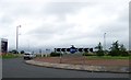
2
Auchinairn Roundabout
Large roundabout on the B812 (Auchinairn Road).
Image: © G Laird
Taken: 13 Nov 2010
0.14 miles
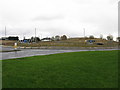
3
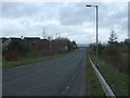
Grassland, Brookfield
A small area of greenspace between Brookfield Drive, Brookfied Avenue and Auchinairn Road (where the car is driving past).
Image: © Richard Sutcliffe
Taken: 16 Jul 2021
0.14 miles
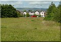
4
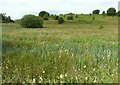
Wet grassland east of Robroyston Road
Image: © Richard Sutcliffe
Taken: 16 Jul 2021
0.18 miles
5
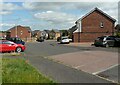
Brookfield Drive
A residential street in Brookfield.
Image: © Richard Sutcliffe
Taken: 16 Jul 2021
0.18 miles
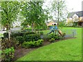
7
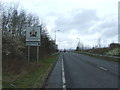
Entering Bishopbriggs, East Dunbartonshire
Heading north west on Robroyston Road.
Image: © JThomas
Taken: 30 Mar 2017
0.22 miles