IMAGES TAKEN NEAR TO
Etive Crescent, GLASGOW, G64 1ES
Introduction
This page details the photographs taken nearby to Etive Crescent, G64 1ES by members of the Geograph project.
The Geograph project started in 2005 with the aim of publishing, organising and preserving representative images for every square kilometre of Great Britain, Ireland and the Isle of Man.

There are currently over 7.5m images from over14,400 individuals and you can help contribute to the project by visiting https://www.geograph.org.uk
Image Map
Images are licensed for reuse under creativecommons.org/licenses/by-sa/2.0
Notes
- Clicking on the map will re-center to the selected point.
- The higher the marker number, the further away the image location is from the centre of the postcode.
Image Listing (13 Images Found)
Images are licensed for reuse under creativecommons.org/licenses/by-sa/2.0
Image
Details
Distance
1
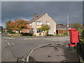
Katrine Avenue / Laggan Road, G64
Shows the location of Image
Image: © Mike Quinn
Taken: 21 Oct 2010
0.10 miles
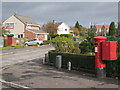
2
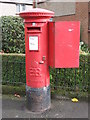
Edward VIII postbox, Katrine Avenue / Laggan Road, G64
Image: © Mike Quinn
Taken: 21 Oct 2010
0.10 miles
3
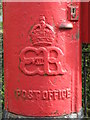
Edward VIII postbox, Katrine Avenue / Laggan Road, G64 - royal cipher
See Image
Image: © Mike Quinn
Taken: 21 Oct 2010
0.10 miles
4
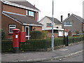
Houses in Katrine Avenue, G64
Shows the location of Image
Image: © Mike Quinn
Taken: 21 Oct 2010
0.13 miles
6
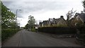
Springfield Road
Houses have a good view of a park on the south side of the road.
Image: © Richard Webb
Taken: 9 May 2012
0.14 miles
7
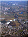
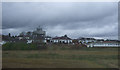
Bishopbriggs and Lenzie from the air
Bishopbriggs is in the foreground. The recently electrified Glasgow to Edinburgh main railway line can be seen.
Image: © Thomas Nugent
Taken: 19 Mar 2018
0.16 miles
8
Site of Bishopbriggs High School
The school building was demolished in June 2010.
Image: © Thomas Nugent
Taken: 24 Aug 2013
0.19 miles
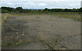
10

Car park, Morrisons
There was a rooftop car park at the previous Morrisons, but now there is a new supermarket, they have built the car park behind it, part of which can be seen here. In the distance is their filling station and in the far distance new homes are under construction.
Image: © Richard Sutcliffe
Taken: 10 Aug 2024
0.21 miles