IMAGES TAKEN NEAR TO
Crosshead Road, GLASGOW, G63 9RN
Introduction
This page details the photographs taken nearby to Crosshead Road, G63 9RN by members of the Geograph project.
The Geograph project started in 2005 with the aim of publishing, organising and preserving representative images for every square kilometre of Great Britain, Ireland and the Isle of Man.

There are currently over 7.5m images from over14,400 individuals and you can help contribute to the project by visiting https://www.geograph.org.uk
Image Map
Images are licensed for reuse under creativecommons.org/licenses/by-sa/2.0
Notes
- Clicking on the map will re-center to the selected point.
- The higher the marker number, the further away the image location is from the centre of the postcode.
Image Listing (110 Images Found)
Images are licensed for reuse under creativecommons.org/licenses/by-sa/2.0
Image
Details
Distance
1
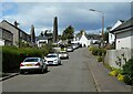
Crosshead Road, Killearn
The Buchanan Monument dominates the view.
Image: © Richard Sutcliffe
Taken: 21 Jul 2023
0.03 miles
2
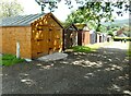
Wooden garages
A row of (mainly) wooden garages of various ages off Crosshead Road.
Image: © Richard Sutcliffe
Taken: 21 Jul 2023
0.04 miles
3

Killearn Primary School
On Crosshead Road.
Image: © Richard Sutcliffe
Taken: 21 Jul 2023
0.04 miles
4
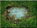
A disappearing grave
This memorial in the churchyard at Killearn Old Parish Church is not of stone, but metal. It is gradually disappearing under the grass. It appears to read:
JANET DOUGALL WIFE OF
M.FLEMING AND T.MORRIS
DIED 7TH JUNE 1909
MARGARET McLAY FLEMING
DIED -- FEBRUARY 1932
Image: © Richard Sutcliffe
Taken: 16 Jun 2019
0.04 miles
5
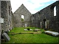
Interior, Old Parish Church, Killearn
The Category B listed church dates from 1734 and is a roofless shell [https://canmore.org.uk/site/44593/killearn-old-parish-church-and-graveyard].
Image: © Richard Sutcliffe
Taken: 16 Jun 2019
0.05 miles
6
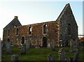
The old kirk, Killearn
Dating from 1734, the Category B listed building http://portal.historicenvironment.scot/designation/LB10387 has been roofless since at least 1836 after the construction of the new church on Balfron Road. It is seen with late afternoon light shining on the walls.
Image: © Richard Sutcliffe
Taken: 10 Feb 2022
0.05 miles
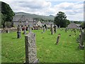
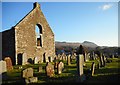
7
Old Parish Church graveyard, Killearn
Looking towards Dumgoyne in the distance.
Image: © Richard Sutcliffe
Taken: 4 Dec 2016
0.05 miles
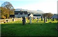
8
Old Cemetery, Killearn
The kirkyard of the ruined old parish church, Killearn.
Image: © Richard Webb
Taken: 1 Jun 2012
0.05 miles
9
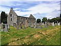
Old Parish Church, Killearn
This roofless church in Killearn is dated 1734, however there are many gravestones in the burial ground that date to the 17th century.
Image: © Euan Nelson
Taken: 10 Jun 2018
0.05 miles
10
Killearn Old Parish Church and graveyard
A Category B listed building, the old parish church was built in 1734, probably replacing an older structure, as there are medieval gravestones in the graveyard.
This church was replaced by a new church in 1826, which was in turn replaced by the current church in 1882 [http://www.geograph.org.uk/photo/4976649].
Image: © Richard Sutcliffe
Taken: 4 Dec 2016
0.05 miles