IMAGES TAKEN NEAR TO
Killearn, GLASGOW, G63 9QY
Introduction
This page details the photographs taken nearby to G63 9QY by members of the Geograph project.
The Geograph project started in 2005 with the aim of publishing, organising and preserving representative images for every square kilometre of Great Britain, Ireland and the Isle of Man.

There are currently over 7.5m images from over14,400 individuals and you can help contribute to the project by visiting https://www.geograph.org.uk
Image Map
Images are licensed for reuse under creativecommons.org/licenses/by-sa/2.0
Notes
- Clicking on the map will re-center to the selected point.
- The higher the marker number, the further away the image location is from the centre of the postcode.
Image Listing (59 Images Found)
Images are licensed for reuse under creativecommons.org/licenses/by-sa/2.0
Image
Details
Distance
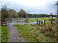
1
Croy Cunningham Steading
See Image for an earlier view, and for some information about the history of these lands. Both pictures were taken from the West Highland Way / John Muir Way.
Image: © Lairich Rig
Taken: 18 Apr 2014
0.01 miles
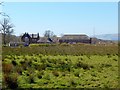
2
Croy Cunningham Steading
This buildings at this site are now a number of separate homes. The photograph was taken from the West Highland Way. See Image for a later picture.
The first-edition OS map of c.1860 shows buildings, labelled "Croy Cunningham", occupying this site. However, the name also applied to the surrounding area; this part of the Croy lands was, in the sixteenth century, in the possession of a certain Alexander Cunninghame (hence the name; there was also a Croy Leckie and a Croy Buchanan).
His daughter married one of the Cunninghames of Drumquhassle; their son Edward got into financial difficulties in about 1668, and "Croy Cunninghame was apprized by Walter Buchanan of the Moss and John Buchanan, younger of Balfunning" [for the subsequent history of the area, see J.G.Smith's "Strathendrick and its Inhabitants from Early Times" (1896), from which the quote was taken].
[Approximate locations of places mentioned above: Drumquhassle – Image; The Moss (a colloquial name for Middle Ledlewan) – Image; Balfunning – Image The Moss has the distinction of being the birthplace of the scholar and historian George Buchanan, as noted on the Pont/Blaeu map of the Lennox (where, beside "The Moss", is written "G. Buchanani patria"); the map also shows the above-mentioned Ledlewan, as "Ladlewens".]
Image: © Lairich Rig
Taken: 30 Jun 2011
0.01 miles
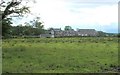
3
Grassy field from the B834
A track crosses the field, leading to a building beside the old railway line, through the trees to the right.
Image: © Richard Sutcliffe
Taken: 29 May 2016
0.14 miles
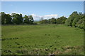
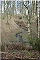
4
Farm track, Croy Cunningham
There would once have been a level crossing here - photograph taken from a railway trackbed.
Image: © Richard Webb
Taken: 17 Aug 2016
0.14 miles
5
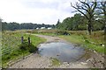
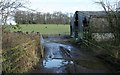
Un-named burn
Looking from the West Highland Way.
Image: © Richard Sutcliffe
Taken: 27 Jan 2019
0.15 miles
7
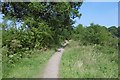
Aberfoyle railway trackbed
Passing Killearn, now used by the West Highland Way.
Image: © Richard Webb
Taken: 17 Aug 2016
0.15 miles
8
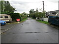
A former section of the A81 at Blane
Looking northward. The A81 now bypasses to the east.
Image: © Peter Wood
Taken: 7 Sep 2022
0.15 miles
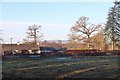
9
Farm building and grazing sheep
Despite it still being January, the sheep had lambs [https://www.geograph.org.uk/photo/6034441].
Image: © Richard Sutcliffe
Taken: 27 Jan 2019
0.16 miles