IMAGES TAKEN NEAR TO
Killearn, GLASGOW, G63 9QW
Introduction
This page details the photographs taken nearby to G63 9QW by members of the Geograph project.
The Geograph project started in 2005 with the aim of publishing, organising and preserving representative images for every square kilometre of Great Britain, Ireland and the Isle of Man.

There are currently over 7.5m images from over14,400 individuals and you can help contribute to the project by visiting https://www.geograph.org.uk
Image Map
Images are licensed for reuse under creativecommons.org/licenses/by-sa/2.0
Notes
- Clicking on the map will re-center to the selected point.
- The higher the marker number, the further away the image location is from the centre of the postcode.
Image Listing (5 Images Found)
Images are licensed for reuse under creativecommons.org/licenses/by-sa/2.0
Image
Details
Distance
2
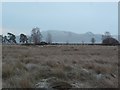
Rashy ground by the Dualt Burn
Very wet pasture.
Image: © Richard Webb
Taken: 17 Aug 2016
0.13 miles
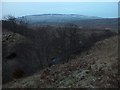
4
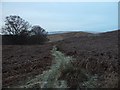
Track near Meikle Caldon
Just west of Stockiemuir Road.
Image: © Stephen Sweeney
Taken: 16 Jan 2010
0.17 miles