IMAGES TAKEN NEAR TO
Killearn, GLASGOW, G63 9QN
Introduction
This page details the photographs taken nearby to G63 9QN by members of the Geograph project.
The Geograph project started in 2005 with the aim of publishing, organising and preserving representative images for every square kilometre of Great Britain, Ireland and the Isle of Man.

There are currently over 7.5m images from over14,400 individuals and you can help contribute to the project by visiting https://www.geograph.org.uk
Image Map
Images are licensed for reuse under creativecommons.org/licenses/by-sa/2.0
Notes
- Clicking on the map will re-center to the selected point.
- The higher the marker number, the further away the image location is from the centre of the postcode.
Image Listing (2 Images Found)
Images are licensed for reuse under creativecommons.org/licenses/by-sa/2.0
Image
Details
Distance
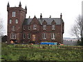
1
Aucheneck House
This is a distant shot, from outwith the OS grid square in which the house is located. For a closer look at the building, see David Robertson's earlier picture: Image
James MacNair, who was well known as a land improver and agriculturalist, purchased the Aucheneck estate in 1828. As well as improving the estate itself, he erected this mansion house. The Aucheneck estate was later purchased from Mr MacNair's trustees by John Wilson, who built a large addition to the house.
Further information can be found in J G Smith's "Strathendrick and its Inhabitants from Early Times" (1896).
Image: © Lairich Rig
Taken: 19 Jul 2013
0.10 miles