IMAGES TAKEN NEAR TO
Dumgoyne, GLASGOW, G63 9QL
Introduction
This page details the photographs taken nearby to G63 9QL by members of the Geograph project.
The Geograph project started in 2005 with the aim of publishing, organising and preserving representative images for every square kilometre of Great Britain, Ireland and the Isle of Man.

There are currently over 7.5m images from over14,400 individuals and you can help contribute to the project by visiting https://www.geograph.org.uk
Image Map
Images are licensed for reuse under creativecommons.org/licenses/by-sa/2.0
Notes
- Clicking on the map will re-center to the selected point.
- The higher the marker number, the further away the image location is from the centre of the postcode.
Image Listing (5 Images Found)
Images are licensed for reuse under creativecommons.org/licenses/by-sa/2.0
Image
Details
Distance
4
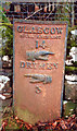
Old Milepost by the A809, Craighat Wood, Killearn Parish
Glasgow curved by the A809, in parish of Killearn (Stirling District), Craighat, on grass verge.
Inscription reads:- : GLASGOW / ROYAL EXCHANGE / 14 / {pointing hand} / DRYMEN / {pointing hand} / 3 :
Surveyed
Milestone Society National ID: ST_GWDR14.
Image: © Milestone Society
Taken: Unknown
0.25 miles
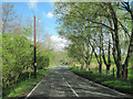
5
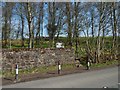
Access to Finnich Glen
The view is from further along the road shown in Image The point shown in the present picture is the usual way by which people now gain access to Image The old steps, or Image, leading down into the glen are on this side (the south).
The sign on the other side of the wall is shown in Image; others like it can be found in various places around the glen; see, for example, Image
Image: © Lairich Rig
Taken: 8 Apr 2019
0.25 miles