IMAGES TAKEN NEAR TO
Killearn, GLASGOW, G63 9QH
Introduction
This page details the photographs taken nearby to G63 9QH by members of the Geograph project.
The Geograph project started in 2005 with the aim of publishing, organising and preserving representative images for every square kilometre of Great Britain, Ireland and the Isle of Man.

There are currently over 7.5m images from over14,400 individuals and you can help contribute to the project by visiting https://www.geograph.org.uk
Image Map
Images are licensed for reuse under creativecommons.org/licenses/by-sa/2.0
Notes
- Clicking on the map will re-center to the selected point.
- The higher the marker number, the further away the image location is from the centre of the postcode.
Image Listing (15 Images Found)
Images are licensed for reuse under creativecommons.org/licenses/by-sa/2.0
Image
Details
Distance
1
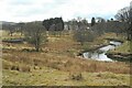
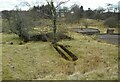
A loop in the Blane Water
The Blane Water meanders here. On the left is the disused sewage works for the nearby former Killearn Hospital. In the distance is Killearn House.
Image: © Richard Sutcliffe
Taken: 9 Mar 2023
0.09 miles
2
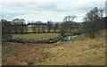
Blane Water
The house in the distance is East Knowe, beside the B834.
Image: © Richard Sutcliffe
Taken: 9 Mar 2023
0.11 miles
3
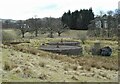
Disused sewage works
The disused sewage works for the nearby former Killearn Hospital. The hospital closed in 1972, so presumably it has been disused since around that time. In the distance on the right is Killearn House.
Image: © Richard Sutcliffe
Taken: 9 Mar 2023
0.14 miles
4
Disused sewage works
The disused sewage works for the nearby former Killearn Hospital. The hospital closed in 1972, so presumably it has been disused since around that time. In the distance is Killearn House.
Image: © Richard Sutcliffe
Taken: 9 Mar 2023
0.14 miles
5
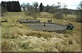
Disused sewage works
The disused sewage works for the nearby former Killearn Hospital. The hospital closed in 1972, so presumably it has been disused since around that time.
Image: © Richard Sutcliffe
Taken: 9 Mar 2023
0.14 miles
6

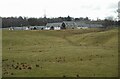
Looking to Home Farm from the south
West of Killearn.
Image: © Stephen Sweeney
Taken: 30 Jun 2013
0.16 miles
7
Croy Buchanan Steading
An exclusive steading development of eleven properties built in 2017, just off the B834. This was previously the site of Home Farm.
Image: © Richard Sutcliffe
Taken: 9 Mar 2023
0.17 miles
8
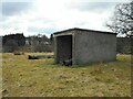
Derelict building
This open-ended building may have been an incinerator for the adjacent hospital, judging by the interior Image
Image: © Richard Sutcliffe
Taken: 9 Mar 2023
0.20 miles
9
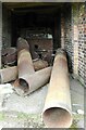
Interior of building
Looking into a derelict building Image Inside are what may be the remains of an incinerator for the adjacent former Killearn Hospital. The large pipes are the remains of a chimney, the base of which is beside the southern side of the building.
Image: © Richard Sutcliffe
Taken: 9 Mar 2023
0.20 miles
10
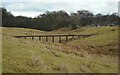
Disused pipeline
Crossing a slight valley beside the former Killearn Hospital. It is probably related to the nearby disused sewage works about 100 metres to the southwest.
Image: © Richard Sutcliffe
Taken: 9 Mar 2023
0.21 miles