IMAGES TAKEN NEAR TO
Endrick Road, GLASGOW, G63 9NQ
Introduction
This page details the photographs taken nearby to Endrick Road, G63 9NQ by members of the Geograph project.
The Geograph project started in 2005 with the aim of publishing, organising and preserving representative images for every square kilometre of Great Britain, Ireland and the Isle of Man.

There are currently over 7.5m images from over14,400 individuals and you can help contribute to the project by visiting https://www.geograph.org.uk
Image Map
Images are licensed for reuse under creativecommons.org/licenses/by-sa/2.0
Notes
- Clicking on the map will re-center to the selected point.
- The higher the marker number, the further away the image location is from the centre of the postcode.
Image Listing (2 Images Found)
Images are licensed for reuse under creativecommons.org/licenses/by-sa/2.0
Image
Details
Distance
2
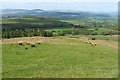
Northern side of Meikle Caldon Hill
The photograph was taken from near the summit of the hill. At the bottom of the slope, part of the buildings of High Finnich (Image) can be seen. See also Image
For distant skyline details, see Image A mast near the left-hand edge of the photograph is the one that is shown in Image
Image: © Lairich Rig
Taken: 22 Apr 2011
0.22 miles