IMAGES TAKEN NEAR TO
Main Street, GLASGOW, G63 9LF
Introduction
This page details the photographs taken nearby to Main Street, G63 9LF by members of the Geograph project.
The Geograph project started in 2005 with the aim of publishing, organising and preserving representative images for every square kilometre of Great Britain, Ireland and the Isle of Man.

There are currently over 7.5m images from over14,400 individuals and you can help contribute to the project by visiting https://www.geograph.org.uk
Image Map
Images are licensed for reuse under creativecommons.org/licenses/by-sa/2.0
Notes
- Clicking on the map will re-center to the selected point.
- The higher the marker number, the further away the image location is from the centre of the postcode.
Image Listing (17 Images Found)
Images are licensed for reuse under creativecommons.org/licenses/by-sa/2.0
Image
Details
Distance
1
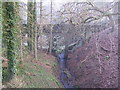
Aqueduct across Kirkhouse Burn, Killearn
This is carrying the water pipes from Loch Katrine to Glasgow
Image: © Chris Upson
Taken: 25 Dec 2005
0.01 miles
2
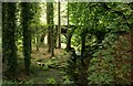
Killearn Aqueduct Bridge
The bridge, which crosses the Kirkhouse Burn, is the best preserved of the 13 stone-built aqueduct bridges at the lower end of the first phase of the Glasgow Corporation Water Works system carrying water from Loch Katrine to Glasgow. It dates from 1856 and is Category B listed http://portal.historicenvironment.scot/designation/LB51139 .
Image: © Richard Sutcliffe
Taken: 15 Sep 2018
0.07 miles
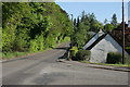
3
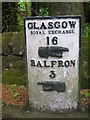
Old Milepost by the A875, Killearn
Glasgow curved by the A875, in parish of Killearn (Stirling District), South of Killearn, near No. 8, near bus stop.
Inscription reads:-
GLASGOW
ROYAL EXCHANGE
16
{hand->}
BALFRON
3
{<-hand}
Surveyed
Milestone Society National ID: ST_GWBF16
Image: © Milestone Society
Taken: Unknown
0.07 miles

5
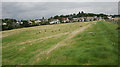
Houses on the edge of Killearn
These properties are on Branziert Road North. Seen from a track to the south.
Image: © Richard Sutcliffe
Taken: 15 Sep 2018
0.13 miles
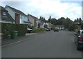
6
Main Street, Killearn
The houses here beside the A875 are built below the level of the road.
Image: © Richard Sutcliffe
Taken: 29 May 2016
0.14 miles
7
Cedar Road, Killearn
One of several streets in the area named after trees.
Image: © Richard Sutcliffe
Taken: 30 Jul 2023
0.17 miles
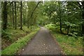
10
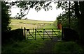
Gate at the end of the road
This is the end of the tarmac road. It continues as a track from here, and joins up with the waterworks road which leads to Strathblane.
Image: © Richard Sutcliffe
Taken: 15 Sep 2018
0.18 miles