IMAGES TAKEN NEAR TO
Dumgoyne, GLASGOW, G63 9LD
Introduction
This page details the photographs taken nearby to G63 9LD by members of the Geograph project.
The Geograph project started in 2005 with the aim of publishing, organising and preserving representative images for every square kilometre of Great Britain, Ireland and the Isle of Man.

There are currently over 7.5m images from over14,400 individuals and you can help contribute to the project by visiting https://www.geograph.org.uk
Image Map
Images are licensed for reuse under creativecommons.org/licenses/by-sa/2.0
Notes
- Clicking on the map will re-center to the selected point.
- The higher the marker number, the further away the image location is from the centre of the postcode.
Image Listing (12 Images Found)
Images are licensed for reuse under creativecommons.org/licenses/by-sa/2.0
Image
Details
Distance
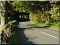
2
Baptiston
A farm beside the A875. Seen from the West Highland Way.
Image: © Richard Sutcliffe
Taken: 11 May 2023
0.09 miles
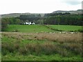
3
Baptiston
On the right, a hedge runs alongside the path that, as shown on 1:50000 map and the 1:25000 map, runs roughly eastwards towards Baptiston. The edge of the Campsie Hills forms the backdrop. The picture was taken from the West Highland Way / John Muir Way.
Image: © Lairich Rig
Taken: 18 Apr 2014
0.12 miles
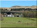
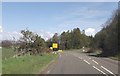
4
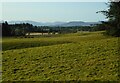
Fields at Dumgoyne
Looking towards the west from the A875.
Image: © Richard Sutcliffe
Taken: 26 Sep 2020
0.14 miles
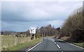
6
A875 junction from A81
The A81 is closed at this time - A diversion in place via A875
Image: © John Firth
Taken: 17 May 2013
0.20 miles
7

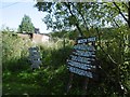
Old Milepost by the A875, Kessock Wood, Baptiston, Killearn parish
Glasgow curved plate by the A875, in parish of Killearn (Stirling District), North of Baptiston, 5m below 'SLOW' on road, almost hidden under Ash tree, East side of road.
Inscription reads:-
GLASGOW
ROYAL EXCHANGE
15
{hand->}
BALFRON
4
{<-hand}
Surveyed
Milestone Society National ID: ST_GWBF15
Image: © Milestone Society
Taken: Unknown
0.22 miles
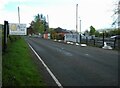
8
The main road through Dumgoyne
The area is called Dumgoyne, named after a prominent nearby hill of the same name. The road is the A81. For the area on the right, see Image and Image, the latter picture having been taken 14 years earlier.
The building on the right is the Image, also shown in Image The present photograph was taken from the point where the West Highland Way crosses the line of the road.
See Image for a view in the opposite direction.
Image: © Lairich Rig
Taken: 30 Jun 2011
0.24 miles
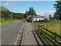
9
The Beech Tree
Cafe, bar and restaurant on the A81 in Dumgoyne. It sits beside the route of the West Highland Way. It is currently (2023) up for sale.
Image: © Richard Sutcliffe
Taken: 11 May 2023
0.24 miles
10
Beech Tree
A very welcoming cafe on the West Highland Way. This is the site of Dumgoyne Station on the long closed Glasgow to Aberfoyle railway.
Image: © Richard Webb
Taken: 17 Aug 2016
0.24 miles