IMAGES TAKEN NEAR TO
Netherblane, GLASGOW, G63 9JP
Introduction
This page details the photographs taken nearby to Netherblane, G63 9JP by members of the Geograph project.
The Geograph project started in 2005 with the aim of publishing, organising and preserving representative images for every square kilometre of Great Britain, Ireland and the Isle of Man.

There are currently over 7.5m images from over14,400 individuals and you can help contribute to the project by visiting https://www.geograph.org.uk
Image Map
Images are licensed for reuse under creativecommons.org/licenses/by-sa/2.0
Notes
- Clicking on the map will re-center to the selected point.
- The higher the marker number, the further away the image location is from the centre of the postcode.
Image Listing (64 Images Found)
Images are licensed for reuse under creativecommons.org/licenses/by-sa/2.0
Image
Details
Distance
1
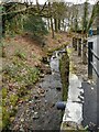
Jenny's Burn
Running alongside Station Road.
Image: © Richard Sutcliffe
Taken: 15 Mar 2022
0.07 miles
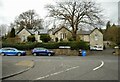
3
Blane Valley Lodge
This was the lodge to Blanefield House, home of the Coubrough family, who owned the nearby printworks.
Image: © Richard Sutcliffe
Taken: 11 Oct 2021
0.08 miles
4
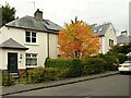
Autumn colours, Blanefield
A tree in a garden in Station Road is putting on a good autumn display.
Image: © Richard Sutcliffe
Taken: 11 Oct 2021
0.08 miles
5
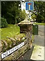
Carved gatepier
This gatepier at the end of a wall leading into Netherblane (a cul-de-sac) is a reminder that this was once the entrance to Blanefield House. It was the home of the Coubrough family, who owned the nearby printworks. The building was demolished to make way for the modern flats built in the 1970s that now occupy the site.
Image: © Richard Sutcliffe
Taken: 11 Oct 2021
0.08 miles
6
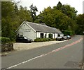
Smithy Gallery, Blanefield
Smithy Gallery is a small contemporary fine art gallery housed in the original village blacksmith's cottage beside the A81 (Glasgow Road).
Image: © Richard Sutcliffe
Taken: 11 Oct 2021
0.09 miles
7
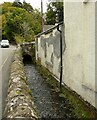
Jenny's Burn
Also known in the past as Netherton Burn, this small stream runs beside Station Road. It has been canalised here and runs between the road and adjacent properties.
Image: © Richard Sutcliffe
Taken: 11 Oct 2021
0.09 miles
8
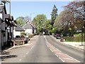
Residential uses along the A81 in Blanefield
Looking uphill along the main highway through the town.
Image: © C Michael Hogan
Taken: 28 Jul 2012
0.09 miles
9
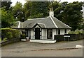
Former primary school
This former school dates from 1883 and served Blanefield until the new primary school was built in 1966. It is situated north of the junction of Station Road (B821) and Glasgow Road (A81).
Image: © Richard Sutcliffe
Taken: 16 Apr 2022
0.10 miles
10
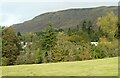
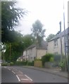
Mixed woodland, Blanefield
The nearest trees are along the line of the Blane Water. The Strathblane Hills are behind.
Image: © Richard Sutcliffe
Taken: 10 Oct 2021
0.10 miles