IMAGES TAKEN NEAR TO
Moor Road, GLASGOW, G63 9EX
Introduction
This page details the photographs taken nearby to Moor Road, G63 9EX by members of the Geograph project.
The Geograph project started in 2005 with the aim of publishing, organising and preserving representative images for every square kilometre of Great Britain, Ireland and the Isle of Man.

There are currently over 7.5m images from over14,400 individuals and you can help contribute to the project by visiting https://www.geograph.org.uk
Image Map
Images are licensed for reuse under creativecommons.org/licenses/by-sa/2.0
Notes
- Clicking on the map will re-center to the selected point.
- The higher the marker number, the further away the image location is from the centre of the postcode.
Image Listing (7 Images Found)
Images are licensed for reuse under creativecommons.org/licenses/by-sa/2.0
Image
Details
Distance
1
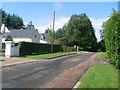
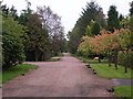
Moor Road
Housing estate south of Strathblane, by Dumbrock Muir.
Image: © Stephen Sweeney
Taken: 3 Aug 2010
0.09 miles
2
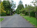
Moor Road, Strathblane
An image to replicate the first submitted for this square in 2005 Image
Image: © Richard Sutcliffe
Taken: 18 Jun 2021
0.13 miles
4
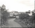
Deil's Craig Dam
South of Strathblane.
Image: © Gerald England
Taken: 4 Oct 1967
0.14 miles
5
Moor Road, Strathblane
Looking east along Moor Road from just before the open ground of Dumbrock Muir
Image: © Chris Upson
Taken: 5 Oct 2005
0.15 miles
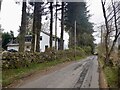
6
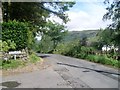
Old Mugdock Road at Moor Road
Near Strathblane.
Image: © Stephen Sweeney
Taken: 3 Aug 2010
0.18 miles
7
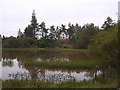
Mill Dam, Strathblane
Looking south across Mill Dam
Image: © Chris Upson
Taken: 5 Oct 2005
0.20 miles