IMAGES TAKEN NEAR TO
Milngavie Road, GLASGOW, G63 9EH
Introduction
This page details the photographs taken nearby to Milngavie Road, G63 9EH by members of the Geograph project.
The Geograph project started in 2005 with the aim of publishing, organising and preserving representative images for every square kilometre of Great Britain, Ireland and the Isle of Man.

There are currently over 7.5m images from over14,400 individuals and you can help contribute to the project by visiting https://www.geograph.org.uk
Image Map
Images are licensed for reuse under creativecommons.org/licenses/by-sa/2.0
Notes
- Clicking on the map will re-center to the selected point.
- The higher the marker number, the further away the image location is from the centre of the postcode.
Image Listing (54 Images Found)
Images are licensed for reuse under creativecommons.org/licenses/by-sa/2.0
Image
Details
Distance
2
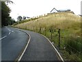
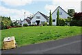
New houses beside Milngavie Road
This area of ground just to the south of Milngavie Road, which was a steep slope with grass and trees has been extensively remodelled over the last couple of years. Eight properties have been built here. The pavement beside Milngavie Road has been resurfaced and new street lights have been installed.
Image: © Richard Sutcliffe
Taken: 25 Jul 2023
0.09 miles
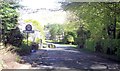
4
Entering Strathblane at bus stop near Milndavie Road
Image: © John Firth
Taken: 17 May 2013
0.11 miles
5
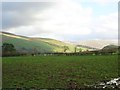
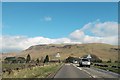
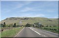
Strathblane, fields at Old Mugdock Road
View towards the Campsie Fells.
Image: © Robert Murray
Taken: 1 Nov 2011
0.14 miles
6
Houses, Old Mugdock Road
These houses are on a short cul-de-sac off the main part of Old Mugdock Road.
Image: © Richard Sutcliffe
Taken: 28 Jul 2024
0.14 miles
7
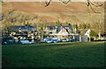
New houses
Two new houses being built on Milndavie Road, Strathblane. They occupy a plot which previously held one house.
Image: © Richard Sutcliffe
Taken: 26 Jan 2023
0.14 miles
8
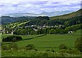
Strathblane
Taken from Dunglass Hill next to the walkway between Strathblane and Lennoxtown.
Image: © Ron Shephard
Taken: 18 May 2008
0.16 miles
9
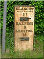
Old Milestonepost by the A81, Milngavie Road, Strathblane parish
Glasgow curved plate by the A81, in parish of Strathblane (Stirling District), South end of Strathblane, North of sharp bend, next to bus stop layby.
Surveyed
Milestone Society National ID: ST_GWAF11
Image: © Milestone Society
Taken: Unknown
0.17 miles
10
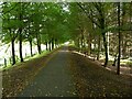
Strathblane Railway Path
Looking east through a woodland section.
Image: © Richard Sutcliffe
Taken: 28 Aug 2021
0.18 miles