IMAGES TAKEN NEAR TO
Menzies Crescent, GLASGOW, G63 0YL
Introduction
This page details the photographs taken nearby to Menzies Crescent, G63 0YL by members of the Geograph project.
The Geograph project started in 2005 with the aim of publishing, organising and preserving representative images for every square kilometre of Great Britain, Ireland and the Isle of Man.

There are currently over 7.5m images from over14,400 individuals and you can help contribute to the project by visiting https://www.geograph.org.uk
Image Map
Images are licensed for reuse under creativecommons.org/licenses/by-sa/2.0
Notes
- Clicking on the map will re-center to the selected point.
- The higher the marker number, the further away the image location is from the centre of the postcode.
Image Listing (8 Images Found)
Images are licensed for reuse under creativecommons.org/licenses/by-sa/2.0
Image
Details
Distance
1
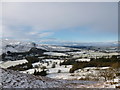
Strath Endrick and Fintry in snow
Light snow cover in the village of Fintry and the valley of the Endrick, viewed from the hillside above Culcreuch Castle.
Image: © Alan O'Dowd
Taken: 17 Jan 2015
0.10 miles
2
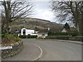
Menzies Avenue
Housing estate on the southern side of Fintry.
Image: © Richard Webb
Taken: 6 Mar 2009
0.11 miles
3
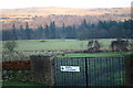
Fintry cemetery
Looking E from position
Image: © Iain Macaulay
Taken: 8 Jan 2006
0.14 miles
4
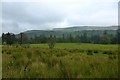
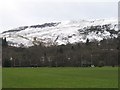
Fintry, rough and good grazing
View to the Campsie Fells.
Image: © Robert Murray
Taken: 8 Sep 2015
0.21 miles
5
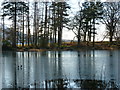
Pond at Culcreuch Castle Hotel
Two ducks waddle across the partially frozen pond.
Image: © Alan O'Dowd
Taken: 6 Feb 2015
0.21 miles
6
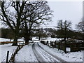
Snowy driveway, Culcreuch Castle Hotel
Light snow cover from showers the previous day.
Image: © Alan O'Dowd
Taken: 17 Jan 2015
0.21 miles
7
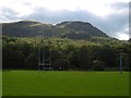
Rugby pitch, Fintry
Pitches at the Fintry Sports Club.
Image: © Richard Webb
Taken: 18 Sep 2015
0.24 miles
8
Rugby pitches, Fintry
A large sports field in Fintry.
Image: © Richard Webb
Taken: 6 Mar 2009
0.25 miles