IMAGES TAKEN NEAR TO
Balfron, GLASGOW, G63 0QR
Introduction
This page details the photographs taken nearby to G63 0QR by members of the Geograph project.
The Geograph project started in 2005 with the aim of publishing, organising and preserving representative images for every square kilometre of Great Britain, Ireland and the Isle of Man.

There are currently over 7.5m images from over14,400 individuals and you can help contribute to the project by visiting https://www.geograph.org.uk
Image Map
Images are licensed for reuse under creativecommons.org/licenses/by-sa/2.0
Notes
- Clicking on the map will re-center to the selected point.
- The higher the marker number, the further away the image location is from the centre of the postcode.
Image Listing (6 Images Found)
Images are licensed for reuse under creativecommons.org/licenses/by-sa/2.0
Image
Details
Distance
2
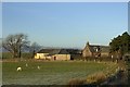
Tombrake Farm Balfron
In the process of being converted into luxury homes
Image: © John Ferguson
Taken: 22 Nov 2009
0.05 miles
4
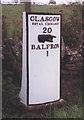
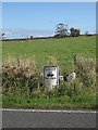
Old Milestone by the A875, Kepculloch Road, Balfron parish
Glasgow curved by the A875, in parish of Balfron (Stirling District), Kepculloch Road, North of Tombrake Farm, on grass verge, East side of road.
Inscription reads:-
GLASGOW
ROYAL EXCHANGE
20
{hand->}
BALFRON
1
Grade C(S) listed.
Reference: LB49016 http://portal.historicenvironment.scot/designation/LB49016
Surveyed
Milestone Society National ID: ST_GWBF20
Image: © Milestone Society
Taken: Unknown
0.14 miles
5
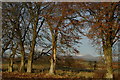
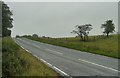
Field & trees north of Tombrake
View towards distant Ben Lomond
Image: © Leslie Barrie
Taken: 11 Nov 2012
0.22 miles