IMAGES TAKEN NEAR TO
Balfron, GLASGOW, G63 0QP
Introduction
This page details the photographs taken nearby to G63 0QP by members of the Geograph project.
The Geograph project started in 2005 with the aim of publishing, organising and preserving representative images for every square kilometre of Great Britain, Ireland and the Isle of Man.

There are currently over 7.5m images from over14,400 individuals and you can help contribute to the project by visiting https://www.geograph.org.uk
Image Map
Images are licensed for reuse under creativecommons.org/licenses/by-sa/2.0
Notes
- Clicking on the map will re-center to the selected point.
- The higher the marker number, the further away the image location is from the centre of the postcode.
Image Listing (4 Images Found)
Images are licensed for reuse under creativecommons.org/licenses/by-sa/2.0
Image
Details
Distance
1
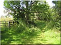
Path, Balfron
A green lane leaves Station Road by the cemetery.
Image: © Richard Webb
Taken: 5 Aug 2010
0.09 miles
2
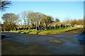
Balfron Cemetery Extension
The cemetery was consecrated in December 2002.
Image: © Richard Sutcliffe
Taken: 10 Feb 2022
0.12 miles
3
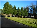
Row of yews
A short row of yew trees along the edge of the entrance path into Balfron Cemetery Extension. The site was consecrated in December 2002. Half of the available ground is still unused.
Image: © Richard Sutcliffe
Taken: 10 Feb 2022
0.13 miles
4
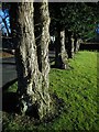
Yew trees
A short row of yew trees along the edge of the entrance path into Balfron Cemetery Extension.
Image: © Richard Sutcliffe
Taken: 10 Feb 2022
0.13 miles