IMAGES TAKEN NEAR TO
Balfron, GLASGOW, G63 0QE
Introduction
This page details the photographs taken nearby to G63 0QE by members of the Geograph project.
The Geograph project started in 2005 with the aim of publishing, organising and preserving representative images for every square kilometre of Great Britain, Ireland and the Isle of Man.

There are currently over 7.5m images from over14,400 individuals and you can help contribute to the project by visiting https://www.geograph.org.uk
Image Map
Images are licensed for reuse under creativecommons.org/licenses/by-sa/2.0
Notes
- Clicking on the map will re-center to the selected point.
- The higher the marker number, the further away the image location is from the centre of the postcode.
Image Listing (10 Images Found)
Images are licensed for reuse under creativecommons.org/licenses/by-sa/2.0
Image
Details
Distance
2
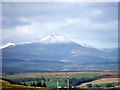
Strathendrick and Ben Lomond
The first snow of the season on the Ben, Scotland's most southerly 'Munro'.
Image: © Robert Murray
Taken: 19 Oct 2011
0.12 miles
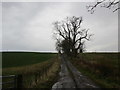
4

Grass field near Wester Ballochearn
Image: © Jonathan Thacker
Taken: 22 Nov 2018
0.17 miles
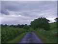
5
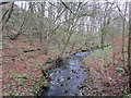
Holm Burn
Looking upstream near Graystone.
Image: © Jonathan Thacker
Taken: 22 Nov 2018
0.22 miles
6
Balglass Burn
Looking NE from position
Image: © Iain Macaulay
Taken: 8 Jan 2006
0.23 miles
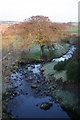
7
Endrick Water at Graystane
View upstream.
Image: © Robert Murray
Taken: 8 Sep 2015
0.24 miles
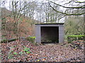
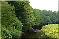
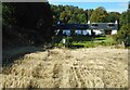
8
Refurbished houses near Graystone
Access to private fishing on Endrick Water.
Image: © Alan Reid
Taken: 17 Dec 2018
0.24 miles
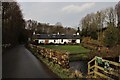
9
Honeyholm Cottages
Self-catering property beside the Endrick Water.
Image: © Richard Sutcliffe
Taken: 26 Sep 2020
0.24 miles