IMAGES TAKEN NEAR TO
Strathview Terrace, GLASGOW, G63 0PS
Introduction
This page details the photographs taken nearby to Strathview Terrace, G63 0PS by members of the Geograph project.
The Geograph project started in 2005 with the aim of publishing, organising and preserving representative images for every square kilometre of Great Britain, Ireland and the Isle of Man.

There are currently over 7.5m images from over14,400 individuals and you can help contribute to the project by visiting https://www.geograph.org.uk
Image Map
Images are licensed for reuse under creativecommons.org/licenses/by-sa/2.0
Notes
- Clicking on the map will re-center to the selected point.
- The higher the marker number, the further away the image location is from the centre of the postcode.
Image Listing (18 Images Found)
Images are licensed for reuse under creativecommons.org/licenses/by-sa/2.0
Image
Details
Distance
1
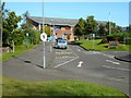
Balfron High School
Seen from Roman Road.
Image: © Richard Sutcliffe
Taken: 7 Sep 2019
0.09 miles
2
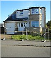
Fire-damaged house, Cotton Street, Balfron
The house was extensively damaged in a fire in July 2019.
Image: © Richard Sutcliffe
Taken: 7 Sep 2019
0.13 miles
3
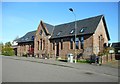
The old Balfron High School
The former High School on Cotton Street. A new school campus was completed close by in 2001, and this building was converted to housing.
Image: © Richard Sutcliffe
Taken: 7 Sep 2019
0.13 miles
4
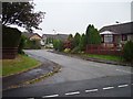
Balfron
Bungaloid close on the eastern side of Balfron.
Image: © Richard Webb
Taken: 17 Sep 2006
0.17 miles
6
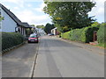
Dunmore Street in Balfron
Looking westward.
Image: © Peter Wood
Taken: 5 Oct 2017
0.19 miles
7
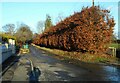
Beech hedge
Along one side of Moor Road, Balfron.
Image: © Richard Sutcliffe
Taken: 10 Feb 2022
0.20 miles
8
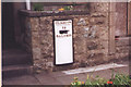
Old Milepost by the A875, Buchanan Street, Balfron parish
Glasgow curved by the A875, in parish of Balfron (Stirling District), Balfron, in wall of No. 92 Buchanan Street.
Inscription reads:-
GLASGOW
ROYAL EXCHANGE
19
{hand->}
BALFRON
HES Grade C(S) listed.
Reference: LB49007 http://portal.historicenvironment.scot/designation/LB49007
Surveyed
Milestone Society National ID: ST_GWBF19
Image: © Milestone Society
Taken: Unknown
0.21 miles
9
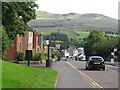
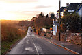
Buchanan Street, Balfron
With a view of the Campsie Fells.
Image: © Richard Webb
Taken: 5 Aug 2010
0.21 miles
10
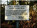
Old sign
The sign beside a gate off Moor Road dates from the days of Central Regional Council and basically says 'Keep Out'. Central Regional Council operated from 1975 to 1996. The grounds are now under Stirling Council.
Image: © Richard Sutcliffe
Taken: 10 Feb 2022
0.22 miles