IMAGES TAKEN NEAR TO
Moor Road, GLASGOW, G63 0PD
Introduction
This page details the photographs taken nearby to Moor Road, G63 0PD by members of the Geograph project.
The Geograph project started in 2005 with the aim of publishing, organising and preserving representative images for every square kilometre of Great Britain, Ireland and the Isle of Man.

There are currently over 7.5m images from over14,400 individuals and you can help contribute to the project by visiting https://www.geograph.org.uk
Image Map
Images are licensed for reuse under creativecommons.org/licenses/by-sa/2.0
Notes
- Clicking on the map will re-center to the selected point.
- The higher the marker number, the further away the image location is from the centre of the postcode.
Image Listing (28 Images Found)
Images are licensed for reuse under creativecommons.org/licenses/by-sa/2.0
Image
Details
Distance
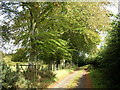
1
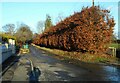
Beech hedge
Along one side of Moor Road, Balfron.
Image: © Richard Sutcliffe
Taken: 10 Feb 2022
0.04 miles
2
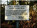
Old sign
The sign beside a gate off Moor Road dates from the days of Central Regional Council and basically says 'Keep Out'. Central Regional Council operated from 1975 to 1996. The grounds are now under Stirling Council.
Image: © Richard Sutcliffe
Taken: 10 Feb 2022
0.07 miles
3
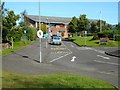
Balfron High School
Seen from Roman Road.
Image: © Richard Sutcliffe
Taken: 7 Sep 2019
0.07 miles
4
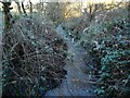
The Clachan Burn
A small burn that joins the Endrick Water about 1.5km downstream.
Image: © Richard Sutcliffe
Taken: 10 Feb 2022
0.08 miles
5
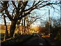
Moor Road
This was photographed just a few metres northeast from Image, which was the first image taken for this square, in 2006. The beech trees, seen on a late afternoon in February look very bare compared with the earlier image.
Image: © Richard Sutcliffe
Taken: 10 Feb 2022
0.08 miles
7
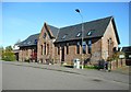
The old Balfron High School
The former High School on Cotton Street. A new school campus was completed close by in 2001, and this building was converted to housing.
Image: © Richard Sutcliffe
Taken: 7 Sep 2019
0.09 miles
8
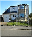
Fire-damaged house, Cotton Street, Balfron
The house was extensively damaged in a fire in July 2019.
Image: © Richard Sutcliffe
Taken: 7 Sep 2019
0.10 miles
9
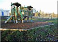
Play area, Donaldson Park
The play area is maintained by Stirling Council and the Donaldson Trust.
Image: © Richard Sutcliffe
Taken: 10 Feb 2022
0.11 miles
10
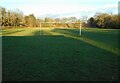
Donaldson Park, Balfron
Home to Balfron Rovers FC, who play in the Forth and Endrick Welfare Football League.
Image: © Richard Sutcliffe
Taken: 10 Feb 2022
0.11 miles