IMAGES TAKEN NEAR TO
Burns Begg Crescent, GLASGOW, G63 0NR
Introduction
This page details the photographs taken nearby to Burns Begg Crescent, G63 0NR by members of the Geograph project.
The Geograph project started in 2005 with the aim of publishing, organising and preserving representative images for every square kilometre of Great Britain, Ireland and the Isle of Man.

There are currently over 7.5m images from over14,400 individuals and you can help contribute to the project by visiting https://www.geograph.org.uk
Image Map
Images are licensed for reuse under creativecommons.org/licenses/by-sa/2.0
Notes
- Clicking on the map will re-center to the selected point.
- The higher the marker number, the further away the image location is from the centre of the postcode.
Image Listing (11 Images Found)
Images are licensed for reuse under creativecommons.org/licenses/by-sa/2.0
Image
Details
Distance
1
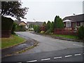
Balfron
Bungaloid close on the eastern side of Balfron.
Image: © Richard Webb
Taken: 17 Sep 2006
0.04 miles
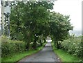
5
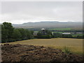
Kilfasset Farm
Kilfasset viewed from the north with the Campsie Fells beyond.
Image: © Scott Cormie
Taken: 20 Aug 2018
0.16 miles
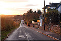
6
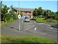
Balfron High School
Seen from Roman Road.
Image: © Richard Sutcliffe
Taken: 7 Sep 2019
0.18 miles
7
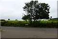
Eastern Fringe of Balfron
The sign says 'Roman Road'. A good distance north of the old Frontier but maybe ......
Image: © Robert Murray
Taken: 8 Sep 2015
0.19 miles
8
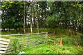
Balfron, Motte
No detail about this on Canmore but a few stories on other local websites.
Image: © Robert Murray
Taken: 8 Sep 2015
0.21 miles
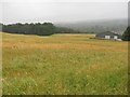
9
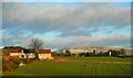
Fields and houses
The houses are on Balglass Drive.
Image: © Richard Sutcliffe
Taken: 10 Feb 2022
0.23 miles
10
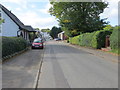
Dunmore Street in Balfron
Looking westward.
Image: © Peter Wood
Taken: 5 Oct 2017
0.23 miles