IMAGES TAKEN NEAR TO
Balfron Station, GLASGOW, G63 0NJ
Introduction
This page details the photographs taken nearby to G63 0NJ by members of the Geograph project.
The Geograph project started in 2005 with the aim of publishing, organising and preserving representative images for every square kilometre of Great Britain, Ireland and the Isle of Man.

There are currently over 7.5m images from over14,400 individuals and you can help contribute to the project by visiting https://www.geograph.org.uk
Image Map
Images are licensed for reuse under creativecommons.org/licenses/by-sa/2.0
Notes
- Clicking on the map will re-center to the selected point.
- The higher the marker number, the further away the image location is from the centre of the postcode.
Image Listing (55 Images Found)
Images are licensed for reuse under creativecommons.org/licenses/by-sa/2.0
Image
Details
Distance
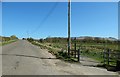
1
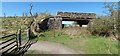
Former railway bridge
As the appearance of the bridge suggests, a railway line used to run under it: the Blane Valley Branch line (NBR). The path that leads SSE from here follows the course of the dismantled line for several kilometres.
Image: © Lairich Rig
Taken: 18 Apr 2014
0.03 miles
2
The West Highland Way at Gartness
Having followed the disused Strathblane railway line north for a somewhat monotonous 4 miles, the Way now leaves it at this point for a bit of road walking
Image: © Tim Heaton
Taken: 12 May 2014
0.03 miles
3
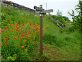
The West Highland Way at Gartness
A fine display of poppies brightening a dull afternoon.
Image: © John Allan
Taken: 4 Jul 2016
0.03 miles
4
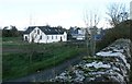
The former Wishing Well Farmhouse Coffee Shop
The coffee shop ceased trading in 2015. A new house is currently under construction in what was the car park. Seen from the parapet of the old bridge over the former railway line.
Image: © Richard Sutcliffe
Taken: 14 Oct 2018
0.04 miles
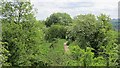
5
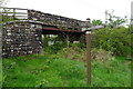
Path leaving Gartness Road
The West Highland Way and the John Muir Way leave Gartness Road here, following the path beyond the gate. About 90 metres ahead, the path makes a sharp right turn, to follow the course of a dismantled railway line: Image
Image: © Lairich Rig
Taken: 18 Apr 2014
0.06 miles
6
Strathendrick and Aberfoyle Railway
The trackbed of this closed railway is now used by an aqueduct and the West Highland Way.
Image: © Richard Webb
Taken: 1 Jun 2012
0.06 miles
7
West Highland Way near Gartness
Line of an old railway called the Blane Valley Branch of the North British Railway (Known as the NBR). Apparently this part of the WHW has also incorporated the new John Muir Way, a trans Scotland path named in honour of John Muir of Dunbar who set up America's national parks like Yellowstone.
Image: © Robert Murray
Taken: 8 Sep 2015
0.06 miles
8
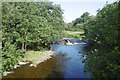
Endrick Water
Looking upstream from the bridge at Gartness.
Image: © Richard Webb
Taken: 17 Aug 2016
0.10 miles
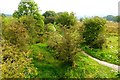
9
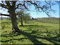
Former field boundary
The line of trees is a reminder of the former presence of a field boundary here, as shown on old OS maps from the first edition (surveyed in 1861) onwards. The house in the background is Gartness Mill Cottage.
Image: © Lairich Rig
Taken: 18 Apr 2014
0.11 miles
10
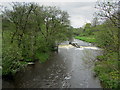
Endrick Water from Gartness Bridge
Looking upstream from the bridge that carries the West Highland Way across Endrick Water
Image: © Chris Heaton
Taken: 12 May 2014
0.11 miles