IMAGES TAKEN NEAR TO
Kippen Road, GLASGOW, G63 0LW
Introduction
This page details the photographs taken nearby to Kippen Road, G63 0LW by members of the Geograph project.
The Geograph project started in 2005 with the aim of publishing, organising and preserving representative images for every square kilometre of Great Britain, Ireland and the Isle of Man.

There are currently over 7.5m images from over14,400 individuals and you can help contribute to the project by visiting https://www.geograph.org.uk
Image Map
Images are licensed for reuse under creativecommons.org/licenses/by-sa/2.0
Notes
- Clicking on the map will re-center to the selected point.
- The higher the marker number, the further away the image location is from the centre of the postcode.
Image Listing (9 Images Found)
Images are licensed for reuse under creativecommons.org/licenses/by-sa/2.0
Image
Details
Distance
1
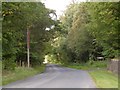
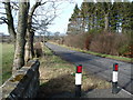
B822
Passing Culcreuch on the way north out of Fintry.
Image: © Richard Webb
Taken: 18 Sep 2015
0.01 miles
2
Culcreuch
A field under the Stronend scarp near Fintry.
Image: © Richard Webb
Taken: 18 Sep 2015
0.04 miles
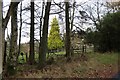
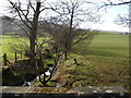
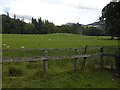
5
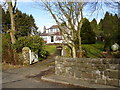
Glynside
It's hard to say whether the name of this house has become corrupted (Glynside) when nearby other mapped names refer to Glinns, but it'll keep locals arguing in the pub for ages...
Image: © Raymond Okonski
Taken: 18 Feb 2007
0.19 miles