IMAGES TAKEN NEAR TO
Balfron, GLASGOW, G63 0LS
Introduction
This page details the photographs taken nearby to G63 0LS by members of the Geograph project.
The Geograph project started in 2005 with the aim of publishing, organising and preserving representative images for every square kilometre of Great Britain, Ireland and the Isle of Man.

There are currently over 7.5m images from over14,400 individuals and you can help contribute to the project by visiting https://www.geograph.org.uk
Image Map
Images are licensed for reuse under creativecommons.org/licenses/by-sa/2.0
Notes
- Clicking on the map will re-center to the selected point.
- The higher the marker number, the further away the image location is from the centre of the postcode.
Image Listing (9 Images Found)
Images are licensed for reuse under creativecommons.org/licenses/by-sa/2.0
Image
Details
Distance
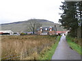
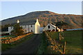
2
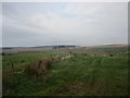
Balafark Farm
The hill in the background is Stronend
Image: © Chris Upson
Taken: 25 Dec 2005
0.04 miles
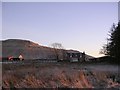
3
Balafark
According to Canmore https://canmore.org.uk/site/358712/balafark, there has been a farmstead here since at least the mid-1700s, as it is depicted on Roy's map.
A small wind turbine seems to be in the process of being erected nearby.
Image: © Richard Sutcliffe
Taken: 26 Sep 2020
0.04 miles
4
Balafark
View across wet grazing land and the Lernock Burn.
Image: © Richard Webb
Taken: 6 Mar 2009
0.05 miles
5
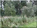
Woodland, Balafark
A small wood beside the B822.
Image: © Richard Webb
Taken: 18 Sep 2015
0.08 miles
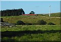
7
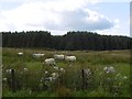
Sheep on Balgair Muir
Coniferous plantations beyond.
Image: © Richard Webb
Taken: 18 Sep 2015
0.11 miles
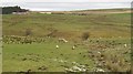
8
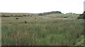
Wet land, Balafark
Very wet pasture beside the Kippen-Fintry road.
Image: © Richard Webb
Taken: 27 Aug 2008
0.14 miles
9
Craigend Farm
Looking SE from position
Stronend in background.
Image: © Iain Macaulay
Taken: 8 Jan 2006
0.17 miles