IMAGES TAKEN NEAR TO
Balfron Station, GLASGOW, G63 0LE
Introduction
This page details the photographs taken nearby to G63 0LE by members of the Geograph project.
The Geograph project started in 2005 with the aim of publishing, organising and preserving representative images for every square kilometre of Great Britain, Ireland and the Isle of Man.

There are currently over 7.5m images from over14,400 individuals and you can help contribute to the project by visiting https://www.geograph.org.uk
Image Map
Images are licensed for reuse under creativecommons.org/licenses/by-sa/2.0
Notes
- Clicking on the map will re-center to the selected point.
- The higher the marker number, the further away the image location is from the centre of the postcode.
Image Listing (15 Images Found)
Images are licensed for reuse under creativecommons.org/licenses/by-sa/2.0
Image
Details
Distance
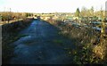
3
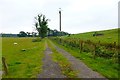
Track at Ballochruin
The small enclosure to the right of the track protects an air shaft connected to the Glasgow water supply pipeline which runs beneath this ground.
Image: © Robert Murray
Taken: 8 Sep 2015
0.06 miles
4
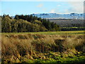
Woodland near Ballochruin Farm
There's a dusting of snow on the Campie Fells in the distance.
Image: © Richard Sutcliffe
Taken: 10 Feb 2022
0.09 miles
5
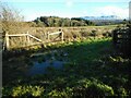
Field entrance
There's a dusting of snow on the Campie Fells in the distance.
Image: © Richard Sutcliffe
Taken: 10 Feb 2022
0.17 miles
6
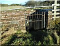
Gate to pipe chamber
The locked gate gives access to steps leading down to an internal valve chamber of the 1855 aqueduct at the northern end of the pipe bridge Image There is a mirror image on the other side of the old roadway. These are included in the Category B listing of the bridge http://portal.historicenvironment.scot/designation/LB51138.
Image: © Richard Sutcliffe
Taken: 10 Feb 2022
0.18 miles
7
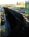
Pipe bridge over the Endrick Water
This is the 1885 girder pipe bridge over the Endrick Water, which carries pipes in a syphon section on the line of the 1885 aqueduct for the Loch Katrine scheme.
Image: © Richard Sutcliffe
Taken: 10 Feb 2022
0.20 miles
8
Glasgow's water pipelines cross the Endrick
Image: © Alan Reid
Taken: 30 Nov 2014
0.20 miles
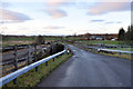
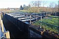
10
Bridge over the Endrick Water
This is the old pipe bridge over the Endrick Water, built in 1865 as part of the Glasgow Corporation Water Works system. It carried a water pipe as well as a road. A burst pipe damaged the bridge in the 1990s, as a result of which a separate replacement road bridge was constructed alongside. The bridge is Category B listed http://portal.historicenvironment.scot/designation/LB51138.
Image: © Richard Sutcliffe
Taken: 10 Feb 2022
0.20 miles