IMAGES TAKEN NEAR TO
Muirpark Way, GLASGOW, G63 0DX
Introduction
This page details the photographs taken nearby to Muirpark Way, G63 0DX by members of the Geograph project.
The Geograph project started in 2005 with the aim of publishing, organising and preserving representative images for every square kilometre of Great Britain, Ireland and the Isle of Man.

There are currently over 7.5m images from over14,400 individuals and you can help contribute to the project by visiting https://www.geograph.org.uk
Image Map
Images are licensed for reuse under creativecommons.org/licenses/by-sa/2.0
Notes
- Clicking on the map will re-center to the selected point.
- The higher the marker number, the further away the image location is from the centre of the postcode.
Image Listing (100 Images Found)
Images are licensed for reuse under creativecommons.org/licenses/by-sa/2.0
Image
Details
Distance
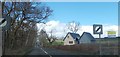
1
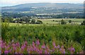
Drymen from the north
Seen from the West Highland Way in Garadhban Forest.
Image: © Richard Sutcliffe
Taken: 2 Aug 2020
0.08 miles
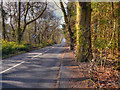
3
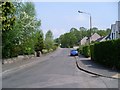
Old Gartmore Road
Leads from Drymen to Gartmore via the Queen Elizabeth Forest Park.
Image: © Stephen Sweeney
Taken: 11 May 2008
0.09 miles
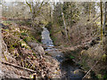
4
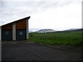
Lomond Mountain Rescue station, with Conic Hill on the horizon
Image: © Elliott Simpson
Taken: 17 May 2008
0.12 miles

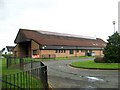
9
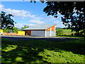
Lomond Mountain Rescue Base
Opened in 2005, just north of Drymen.
Image: © John Allan
Taken: 5 Jul 2016
0.15 miles
10
Drymen Village Hall
The village hall is on Old Gartmore Road at the northern end of the village.
Image: © David Dixon
Taken: 17 Apr 2012
0.15 miles