IMAGES TAKEN NEAR TO
Charles Crescent, GLASGOW, G63 0BS
Introduction
This page details the photographs taken nearby to Charles Crescent, G63 0BS by members of the Geograph project.
The Geograph project started in 2005 with the aim of publishing, organising and preserving representative images for every square kilometre of Great Britain, Ireland and the Isle of Man.

There are currently over 7.5m images from over14,400 individuals and you can help contribute to the project by visiting https://www.geograph.org.uk
Image Map
Images are licensed for reuse under creativecommons.org/licenses/by-sa/2.0
Notes
- Clicking on the map will re-center to the selected point.
- The higher the marker number, the further away the image location is from the centre of the postcode.
Image Listing (99 Images Found)
Images are licensed for reuse under creativecommons.org/licenses/by-sa/2.0
Image
Details
Distance
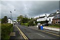
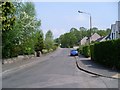
1
Charles Crescent, Drymen
Residential street in the village.
Image: © Stephen Sweeney
Taken: 11 May 2008
0.02 miles
2

Kip in the Kirk at Drymen
Formerly a church, now a hostel and an overnight stop on the West Highland Way.
Image: © Peter S
Taken: 31 May 2014
0.04 miles

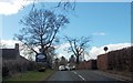
4
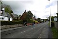
Stirling Road, Drymen
Heading for the West Highland Way.
Image: © Richard Webb
Taken: 14 May 2017
0.06 miles
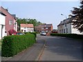
5
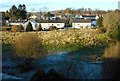
Houses on Ardmore Gardens, Drymen
Seen across frosty ground from Gartness Road.
Image: © Richard Sutcliffe
Taken: 29 Nov 2019
0.08 miles
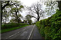
7
Old Gartmore Road
Leads from Drymen to Gartmore via the Queen Elizabeth Forest Park.
Image: © Stephen Sweeney
Taken: 11 May 2008
0.09 miles
8
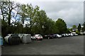
Car park, Drymen
Very popular as it is still free.
Image: © Richard Webb
Taken: 14 May 2017
0.09 miles