IMAGES TAKEN NEAR TO
Cattermills, GLASGOW, G63 0BB
Introduction
This page details the photographs taken nearby to Cattermills, G63 0BB by members of the Geograph project.
The Geograph project started in 2005 with the aim of publishing, organising and preserving representative images for every square kilometre of Great Britain, Ireland and the Isle of Man.

There are currently over 7.5m images from over14,400 individuals and you can help contribute to the project by visiting https://www.geograph.org.uk
Image Map
Images are licensed for reuse under creativecommons.org/licenses/by-sa/2.0
Notes
- Clicking on the map will re-center to the selected point.
- The higher the marker number, the further away the image location is from the centre of the postcode.
Image Listing (46 Images Found)
Images are licensed for reuse under creativecommons.org/licenses/by-sa/2.0
Image
Details
Distance
1
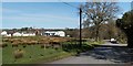
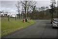
Road leading into Croftamie
Ahead, a van is parked near the junction where this road meets the main road through the village. The large white building a little left of centre is a branch of Scottish Stove Centre. Further to the left is a cluster of buildings making up Image The red sandstone building visible behind the right-hand side of the farm is Image
Image: © Lairich Rig
Taken: 30 Mar 2012
0.07 miles
2
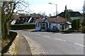
Croftamie Village Store
The shop was not open when this picture was taken. It stands alongside the main road through the village.
Image: © Lairich Rig
Taken: 30 Mar 2012
0.07 miles
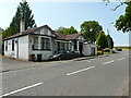
3
Croftamie Village Store and Post Office
Image: © Stephen Sweeney
Taken: 3 Jul 2013
0.07 miles
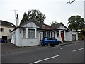
4
Former village store
Croftamie's former village store and post office has been shut for several years.
Image: © Richard Sutcliffe
Taken: 2 Jul 2021
0.08 miles
5
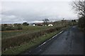
Road junction, Croftamie
Junction of a minor road with the A809.
Image: © Richard Sutcliffe
Taken: 1 Mar 2016
0.09 miles
6
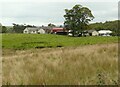
Croftamie Farm
Seen from the minor road to the southwest of the village.
Image: © Richard Sutcliffe
Taken: 20 Sep 2021
0.09 miles
7

Croftamie Farm
The building on the right is the Scottish Stove Centre.
Image: © Richard Sutcliffe
Taken: 2 Jul 2021
0.09 miles
8
Croftamie from the west
Viewed from the minor road to Pirniehall.
Image: © Richard Sutcliffe
Taken: 1 Mar 2016
0.09 miles
9
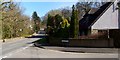
Entrance to Cattermills
Cattermills is a residential development in the village of Croftamie. See Image for further details.
On the left is the main road leading through the village; ahead on that road is a Image
Image: © Lairich Rig
Taken: 30 Mar 2012
0.10 miles
10
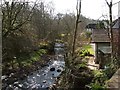
The Catter Burn
This is the view from a Image in the village of Image The houses on the right are in a residential development called Cattermills (Image). There were, at various times, a sawmill (see Image) and a corn mill beside the burn, on the NW side (the area that is on the right in this photograph), as well as a quarry.
The place-name Cattermills appears to be older than the name Croftamie: Roy's Military Survey (1740s-50s) shows a Cautermill here. On the subject of names, there is a Spittal just to the east of the village of Croftamie. This was Spittal of Easter Catter, or, as it once was, the Temple Lands of Easter Catter; compare http://www.geograph.org.uk/photo/1423575
See http://www.valeofleven.org.uk/eastlochlomond.html#croftamie (at the Vale of Leven website) for a useful discussion of the various local industries.
Image: © Lairich Rig
Taken: 30 Mar 2012
0.10 miles