IMAGES TAKEN NEAR TO
Drymen, GLASGOW, G63 0AU
Introduction
This page details the photographs taken nearby to G63 0AU by members of the Geograph project.
The Geograph project started in 2005 with the aim of publishing, organising and preserving representative images for every square kilometre of Great Britain, Ireland and the Isle of Man.

There are currently over 7.5m images from over14,400 individuals and you can help contribute to the project by visiting https://www.geograph.org.uk
Image Map (Loading...)


Getting Data...Please wait
Leaflet Map data © OpenStreetMap
Images are licensed for reuse under creativecommons.org/licenses/by-sa/2.0
Notes
- Clicking on the map will re-center to the selected point.
- The higher the marker number, the further away the image location is from the centre of the postcode.
Image Listing (2 Images Found)
Images are licensed for reuse under creativecommons.org/licenses/by-sa/2.0
Image
Details
Distance
1
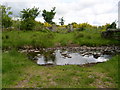
A ford on the farm track to High Mains
Image: © Chris Townsend
Taken: 6 Jun 2009
0.14 miles
2
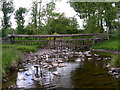
Fence alongside ford at High Mains
This fence, running across the ford which leads to High Mains Farm, Milton of Buchanan, ensures that the pasture to the west of the farm is completely enclosed.
Image: © Chris Townsend
Taken: 6 Jun 2009
0.14 miles