IMAGES TAKEN NEAR TO
Drymen, GLASGOW, G63 0AT
Introduction
This page details the photographs taken nearby to G63 0AT by members of the Geograph project.
The Geograph project started in 2005 with the aim of publishing, organising and preserving representative images for every square kilometre of Great Britain, Ireland and the Isle of Man.

There are currently over 7.5m images from over14,400 individuals and you can help contribute to the project by visiting https://www.geograph.org.uk
Image Map
Images are licensed for reuse under creativecommons.org/licenses/by-sa/2.0
Notes
- Clicking on the map will re-center to the selected point.
- The higher the marker number, the further away the image location is from the centre of the postcode.
Image Listing (8 Images Found)
Images are licensed for reuse under creativecommons.org/licenses/by-sa/2.0
Image
Details
Distance
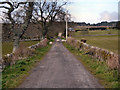
3
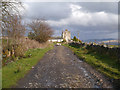
Private Road To Ardyle
The public path bends to the right; the gate and the sign on the tree indicate that the way ahead is a private road.
Image: © David Dixon
Taken: 17 Apr 2012
0.13 miles
4
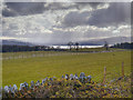
Loch Lomond View
A view over the farmland at Coldrach, looking towards the southern end of Loch Lomond.
Image: © David Dixon
Taken: 17 Apr 2012
0.16 miles

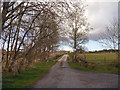
7
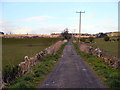
Track Towards Angel Plantation
The track from Buchanan Smithy
Image: © David Dixon
Taken: 17 Apr 2012
0.21 miles