IMAGES TAKEN NEAR TO
Ellangowan Court, GLASGOW, G62 8PH
Introduction
This page details the photographs taken nearby to Ellangowan Court, G62 8PH by members of the Geograph project.
The Geograph project started in 2005 with the aim of publishing, organising and preserving representative images for every square kilometre of Great Britain, Ireland and the Isle of Man.

There are currently over 7.5m images from over14,400 individuals and you can help contribute to the project by visiting https://www.geograph.org.uk
Image Map
Images are licensed for reuse under creativecommons.org/licenses/by-sa/2.0
Notes
- Clicking on the map will re-center to the selected point.
- The higher the marker number, the further away the image location is from the centre of the postcode.
Image Listing (812 Images Found)
Images are licensed for reuse under creativecommons.org/licenses/by-sa/2.0
Image
Details
Distance
1
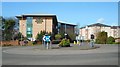
Milngavie Enterprise Centre
Milngavie Enterprise Centre is a modern office development with 18 individual office suites, a small meeting room, staffed reception, and shared toilet and kitchen facilities.
The roundabout is at the junction of Mugdock Road, Ellangowan Road and Ellangowan Court.
Image: © Richard Sutcliffe
Taken: 7 Apr 2020
0.01 miles
2

Ellangowan Mills Branch
Former railway now used by the West Highland Way as it leaves Milngavie.
Image: © Richard Webb
Taken: 17 Aug 2016
0.02 miles
4
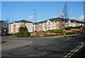
Blocks of flats
On Ellangowan Court, Milngavie.
Image: © Richard Sutcliffe
Taken: 7 Apr 2020
0.02 miles
5
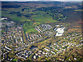
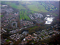
Milngavie from the air
Looking over the north west corner of the town to open countryside and the Kilpatrick Hills.
Image: © Thomas Nugent
Taken: 24 Jan 2020
0.02 miles
6
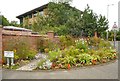
A colourful corner
The corner of Allander Road and Ellangowan Road currently has a very attractive floral display for everyone to enjoy. I suspect this has been produced by members of Milngavie in Bloom, who have been making Milngavie look colourful for several years.
Image: © Richard Sutcliffe
Taken: 10 Aug 2020
0.02 miles
7

Bridge over the West Highland Way
The bridge carries Allander Road over the long distance path. This section of the route follows a former railway cutting. A railway line spur ran here connecting the former Ellangowan Paper Mills to Milngavie Station and onwards towards Glasgow.
Image: © Richard Sutcliffe
Taken: 18 Feb 2020
0.03 miles
8
Milngavie from the air
Looking over Mugdock Road and Clober Road to Clober Golf Club.
Image: © Thomas Nugent
Taken: 3 Nov 2017
0.03 miles
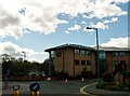
9
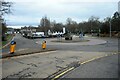
Roundabout, Mugdock Road
Mugdock Road is to the left, Ellengowan Road straight on.
Image: © Richard Sutcliffe
Taken: 1 Feb 2023
0.03 miles
10
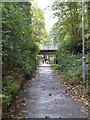
West Highland Way near Milngavie
Looking South back towards the start of the path.
Image: © Dave Kelly
Taken: 3 Oct 2014
0.03 miles