IMAGES TAKEN NEAR TO
Mugdock Road, GLASGOW, G62 8NP
Introduction
This page details the photographs taken nearby to Mugdock Road, G62 8NP by members of the Geograph project.
The Geograph project started in 2005 with the aim of publishing, organising and preserving representative images for every square kilometre of Great Britain, Ireland and the Isle of Man.

There are currently over 7.5m images from over14,400 individuals and you can help contribute to the project by visiting https://www.geograph.org.uk
Image Map
Images are licensed for reuse under creativecommons.org/licenses/by-sa/2.0
Notes
- Clicking on the map will re-center to the selected point.
- The higher the marker number, the further away the image location is from the centre of the postcode.
Image Listing (187 Images Found)
Images are licensed for reuse under creativecommons.org/licenses/by-sa/2.0
Image
Details
Distance
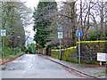
1
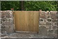
Gate into Barloch Moor
This new gate (installed sometime during the last 12 months) leads from Mugdock Road into Barloch Moor (a local park). Someone has left a square stone, painted in rainbow colours beside it. A sign of the times during the Coronavirus (Covid-19) pandemic, when the rainbow became a sign of support for the NHS.
Image: © Richard Sutcliffe
Taken: 13 May 2020
0.04 miles
2
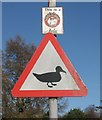
Beware ducks!
Warning sign on Tannoch Drive, beside Tannoch Loch. The loch is a popular place to feed the mallard, tufted ducks and other aquatic birds which use the loch, and they will often cross the road in search of a few more crumbs.
Image: © Richard Sutcliffe
Taken: 28 Mar 2016
0.04 miles
3
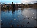
Tannoch Loch, Milngavie
A small loch in a residential area, much loved by wildfowl and locals. Campsie Fells in the distance beyond the woodland.
Image: © Andrew McEwan
Taken: 15 Nov 2005
0.05 miles
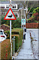
4
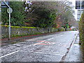
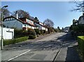
Mugdock Road
Fading warning sign and lines painted on the road at the junction with Mosspark Road.
Image: © Thomas Nugent
Taken: 4 Jan 2018
0.05 miles
5
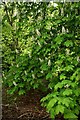
Horse chestnut, Barloch Moor
In full flower.
Image: © Richard Sutcliffe
Taken: 13 May 2020
0.05 miles
6
Mosspark Road
Twenty's Plenty on this dead end road off Mugdock Road.
Image: © Thomas Nugent
Taken: 4 Jan 2018
0.05 miles
7
Mosspark Road
Leading to Mosspark Avenue, St Edmunds Grove and St Edmunds Lane, from Mugdock Road.
Image: © Thomas Nugent
Taken: 4 Jan 2018
0.05 miles
8
Duck crossing sign
On Tannoch Drive, on the approach to Tannoch Loch.
Image: © Thomas Nugent
Taken: 4 Jan 2018
0.05 miles
9
Sandfield Avenue
Looking from Woodlands Street.
Image: © Richard Sutcliffe
Taken: 20 Apr 2022
0.05 miles
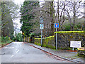
10
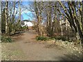
Path out of the park
One of the paths at Barloch Moor, leading onto Mugdock Road.
Image: © Richard Sutcliffe
Taken: 30 Mar 2022
0.05 miles