IMAGES TAKEN NEAR TO
Mugdock, Milngavie, GLASGOW, G62 8LG
Introduction
This page details the photographs taken nearby to G62 8LG by members of the Geograph project.
The Geograph project started in 2005 with the aim of publishing, organising and preserving representative images for every square kilometre of Great Britain, Ireland and the Isle of Man.

There are currently over 7.5m images from over14,400 individuals and you can help contribute to the project by visiting https://www.geograph.org.uk
Image Map
Images are licensed for reuse under creativecommons.org/licenses/by-sa/2.0
Notes
- Clicking on the map will re-center to the selected point.
- The higher the marker number, the further away the image location is from the centre of the postcode.
Image Listing (9 Images Found)
Images are licensed for reuse under creativecommons.org/licenses/by-sa/2.0
Image
Details
Distance
3
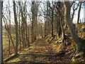
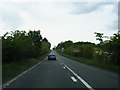
Easterton of Mugdock
The road to Mugdock from Strathblane Road.
Image: © Robert Murray
Taken: 1 Nov 2011
0.12 miles
4
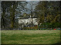
![Mugdock, pasture [2]](https://s3.geograph.org.uk/geophotos/02/68/00/2680059_8c0f7771_120x120.jpg)
Mugdock, pasture [2]
View towards Craigash.
Image: © Robert Murray
Taken: 1 Nov 2011
0.17 miles
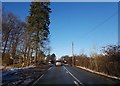
5
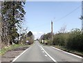
Easterton House
Seen through the trees from the A81.
Image: © Richard Sutcliffe
Taken: 18 Apr 2023
0.17 miles
8
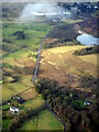
Craigmaddie from the air
The A81 Strathblane Road runs vertically through the scene.
Image: © Thomas Nugent
Taken: 24 Jan 2020
0.21 miles
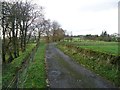
9
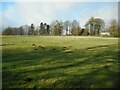
Molehills in a field
Beside the A81. Easterton House can be seen through the trees on the right.
Image: © Richard Sutcliffe
Taken: 18 Apr 2023
0.24 miles