IMAGES TAKEN NEAR TO
Strathblane Road, GLASGOW, G62 8LF
Introduction
This page details the photographs taken nearby to Strathblane Road, G62 8LF by members of the Geograph project.
The Geograph project started in 2005 with the aim of publishing, organising and preserving representative images for every square kilometre of Great Britain, Ireland and the Isle of Man.

There are currently over 7.5m images from over14,400 individuals and you can help contribute to the project by visiting https://www.geograph.org.uk
Image Map
Images are licensed for reuse under creativecommons.org/licenses/by-sa/2.0
Notes
- Clicking on the map will re-center to the selected point.
- The higher the marker number, the further away the image location is from the centre of the postcode.
Image Listing (22 Images Found)
Images are licensed for reuse under creativecommons.org/licenses/by-sa/2.0
Image
Details
Distance
1
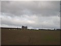
House on a Hill
Near Craigmaddie Reservoir
Image: © Lynn M Reid
Taken: 18 Mar 2008
0.03 miles
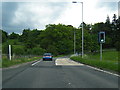
2
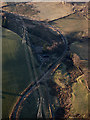
Craigash power lines from the air
The curving track leads from the A81 Strathblane Road to the water treatment works at the Milngavie reservoirs.
Image: © Thomas Nugent
Taken: 8 Dec 2017
0.10 miles
3
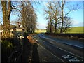
A81 beside Craigmaddie Lodge
The 'Keep Clear' markings on the side of the road are to remind motorists not to park here when wanting to access the paths around the adjacent reservoir.
Image: © Richard Sutcliffe
Taken: 5 Jan 2022
0.15 miles
6
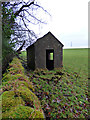
Hut near Craigmaddie Reservoir
At the edge of a field at the north east side of the reservoir.
Image: © Thomas Nugent
Taken: 4 Jan 2018
0.19 miles
7
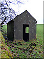
Hut near Craigmaddie Reservoir
At the edge of a field at the north east side of the reservoir.
Image: © Thomas Nugent
Taken: 4 Jan 2018
0.19 miles
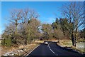
8
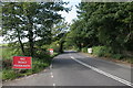
Resurfacing on the A81
The section of the A81 from here into Milngavie has recently been resurfaced. There are no road markings, and a 20 MPH speed limit is in place, due to loose chippings.
Image: © Richard Sutcliffe
Taken: 5 Sep 2015
0.19 miles
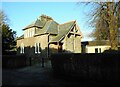
9
Craigmaddie Lodge
Also known as North Lodge, built as lodge houses for Glasgow Corporation water works around 1900. Category C Listed http://portal.historicenvironment.scot/designation/LB51264 .
Image: © Thomas Nugent
Taken: 4 Jan 2018
0.20 miles
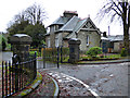
10
Craigmaddie Lodge
Also known as North Lodge, this house was built in the late 1890s. It is the gate lodge to Craigmaddie Reservoir and is situated in a prominent position on Strathblane Road (A81). It is Category C listed http://portal.historicenvironment.scot/designation/LB51264. See also Canmore https://canmore.org.uk/site/292270/glasgow-corporation-waterworks-craigmaddie-lodge.
Image: © Richard Sutcliffe
Taken: 5 Jan 2022
0.20 miles