IMAGES TAKEN NEAR TO
Milngavie, GLASGOW, G62 8LE
Introduction
This page details the photographs taken nearby to G62 8LE by members of the Geograph project.
The Geograph project started in 2005 with the aim of publishing, organising and preserving representative images for every square kilometre of Great Britain, Ireland and the Isle of Man.

There are currently over 7.5m images from over14,400 individuals and you can help contribute to the project by visiting https://www.geograph.org.uk
Image Map
Images are licensed for reuse under creativecommons.org/licenses/by-sa/2.0
Notes
- Clicking on the map will re-center to the selected point.
- The higher the marker number, the further away the image location is from the centre of the postcode.
Image Listing (25 Images Found)
Images are licensed for reuse under creativecommons.org/licenses/by-sa/2.0
Image
Details
Distance
1
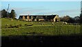
Properties close to Bankell Farm
Sheep are grazing in the field between the A81 and the properties.
Image: © Richard Sutcliffe
Taken: 5 Jan 2022
0.11 miles
2
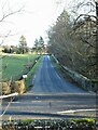
Road to Bankell Farm
Off the A81. Seen from the Craigmaddie Reservoir path.
Image: © Richard Sutcliffe
Taken: 5 Jan 2022
0.12 miles
3
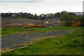
Excavations by Scottish Water
A large area of ground is disturbed close to Bankell Farm due to work being undertaken by Scottish Water. This is in relation to the installation of a new pumping station and 4.3 miles of new plastic twin-pipe water main from Bankell Service Reservoir to Baljaffray Service Reservoir, west of Milngavie.
Image: © Richard Sutcliffe
Taken: 28 Apr 2020
0.14 miles
4
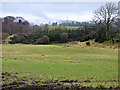
Farlmland near Milngavie
At the site of the former Hillend Farm.
Image: © Thomas Nugent
Taken: 4 Jan 2018
0.20 miles
5
Replanted woodland
New trees replace old in a small piece of woodland on the south side of Strathblane Road.
Image: © Thomas Nugent
Taken: 4 Jan 2018
0.21 miles
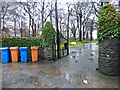
6
Entrance to Bankell Farm
New development coming soon.
Image: © Thomas Nugent
Taken: 4 Jan 2018
0.21 miles
7
Entrance to Bankell Farm
The sign informs that the campsite is now closed.
Image: © Thomas Nugent
Taken: 4 Jan 2018
0.21 miles
8
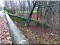
Wall by the A81 Strathblane Road
A section of the south side of the road has a second wall, possibly the extent of the water works property as some water works related features can be seen there.
See also Image & Image
Image: © Thomas Nugent
Taken: 4 Jan 2018
0.21 miles
9
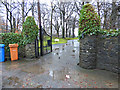
Gate to Bankell House
Off the A81 Strathblane Road.
Image: © Thomas Nugent
Taken: 4 Jan 2018
0.21 miles
10
Gate to Bankell House
Off the A81 Strathblane Road.
Image: © Thomas Nugent
Taken: 4 Jan 2018
0.21 miles